TABLE OF CONTENTS
INTRODUCTION 3
Purpose and Context of the Plan 3
Background 3
Park Purpose 4
Park Significance 4
Interpretive Mission 5
Primary Interpretive Themes 5
Visitor Experience Goals 7
Existing Visitor Experience and Conditions 8
Visitation and Visitor Use Patterns 12
IMPLEMENTATION STRATEGIES 16
Information and Orientation 16
Pre-Arrival 16
On-Arrival 17
Interpretation 18
Nisqually Visitor Center 19
Route 410 Shuttle Staging Center 20
Packwood & Naches Visitor Contact Centers 21
Wilkeson Visitor Contact Center 21
Longmire 22
Paradise 23
Sunrise/White River 26
Ohanapecosh 28
Education Program 29
Roads and Trails 30
Campgrounds and Amphitheaters 31
Publications 31
SUMMARIES 33
Special Populations 33
Staffing and Training 34
Products and Initial Priorities 35
Planning Team and Consultants 40
APPENDICIES 41
Purpose and Context of the Plan
This long-range interpretive plan (LRIP) for Mount Rainier National Park (MORA) is a component of the Park's comprehensive interpretive plan (CIP), as outlined in the National Park Service Interpretive Guidelines (NPS-6). Using the park's mission, purpose, and resource significance statements, plus the primary interpretive themes and visitor experience goals, this plan articulates the visions for the park's interpretive future, and recommends the media and programs best suited for meeting visitor needs, achieving management goals, and telling the park stories. These foundation elements come directly from- or are based on- similar statements in the park's Strategic Plan and in the current draft of the General Management Plan (GMP).
Mount Rainier National Park has never had a park-wide interpretive plan. This fact is amazing, considering that Mount Rainier is the fifth oldest park in the National Park system. The only long-range interpretive planning document on record is a 1976 Interpretive Prospectus for Longmire.
The current long-range interpretive planning effort has proceeded separately, but in tandem with a new park-wide GMP. Interpretive and educational proposals in the GMP are expanded and described in greater detail in this implementation plan. This interpretive plan also responds to the GMP proposals to reduce visitor congestion in some areas of the park, redirect the interpretive focus of interpretive facilities inside the park, and create several external visitor facilities. Two primary GMP recommendations which affect interpretation are the replacement of the Jackson Visitor Center (JVC) at Paradise and the establishment of a main park visitor center outside the Nisqually entrance to the park .
Much of the interpretive media in the park is outdated and some, in fact, is inaccurate in light of current research. Accurate and sufficient information is lacking in some areas- information that is important for visitor safety and enjoyment, and information necessary for understanding and appreciating the park's primary themes and resources.
This plan is not an end in itself, but rather, it establishes the overall framework for the next phases of the process- program planning, and media planning, design, and production over the next 10-15 years. Further, as stated in NPS-6, the park also needs to develop an Annual Interpretive Plan and an Interpretive Database to complete the CIP.
Background
Mount Rainier National Park is located west of the crest of the Cascade Range, approximately 65 miles southwest of the Seattle-Tacoma metropolitan area and 65 miles west of Yakima. Mount Rainier towers 8,000 feet above the surrounding Cascade summits and dominates the Puget Sound landscape.
Mount Rainier was established as a National Park on March 2, 1899. The enabling legislation states that the park was set apart as a public park:
The park is also administered under the provisions of the Organic Act of 1916, which specifies that units of the national park system are:
The purpose of Mount Rainier National Park is found in the above legislation establishing the park and creating the NPS. Specifically, Mount Rainier National Park is to be managed to:
The resources of Mount Rainier National Park are significant for the following reasons:
"The Division of Interpretation and Education seeks to preserve the natural and cultural resources of Mount Rainier National Park through effective interpretation and education services that reveal meanings of park resources and inspire people to protect the park for future generations. Our work reflects professional excellence and is accomplished through initiative, integrity, maturity, and interdependence. Our goal is to leave a legacy of great love for the national parks."
Primary Interpretive Themes
Primary interpretive themes are those ideas/concepts about Mount Rainier National Park that hopefully every visitor will understand. These themes, which are based on the park's mission, purpose, and resource meanings and significance, provide the foundation for all interpretive media and programs in the park. The themes do not include everything that may be interpreted, but they do address those ideas that are critical to understanding and appreciating the park's importance. All interpretive efforts (through both media and personal services) should relate to one or more of the themes, and each theme should be addressed by some part of the overall interpretive program.
The following theme statements, divided into major topics, will provide the basis for interpretation at Mount Rainier National Park. The topics and primary themes appear in bold, followed by key supporting subtheme statements.
Mount Rainier is an active volcano that shapes the landscape and influences processes both within and beyond the park boundary.
Subthemes:
The glaciers on Mount Rainier are dynamic forces of change in the mountain's form and appearance. The glaciers are a continuous source of water for downstream communities and ecosystems, and are a record of environmental conditions of the region.
There is a long history of human interaction with the mountain. Mount Rainier has always shaped the lives and character of the area's human inhabitants.
Subthemes:
As Euro-American explorers, pioneers, and settlers moved into the surrounding region, many were drawn by the beauty, challenges, and opportunities the mountain afforded. Concern for the mountain's future ultimately led to the establishment of Mount Rainier as a national park.
Using local materials and designed to harmonize with the natural setting, some of Mount Rainier National Park's architecture exemplifies the best of the rustic style. These structures, along with roads, trails, and bridges, now comprise a National Historic Landmark District which represents the best of early park planning efforts.
Mount Rainier has offered, and continues to offer a multitude of recreational opportunities from the earliest climbing and camping to modern hiking and sightseeing. The mountain has been a mecca for recreational climbing since early times, and still attracts thousands of climbers each year.
Subthemes:
Mount Rainier's old-growth forests support a rich diversity of flora and fauna, comprising one of the densest biomasses on Earth. The prime stands of old-growth forests on Mount Rainier's lower slopes are an invaluable remnant of those once occupying much of the Puget Sound Basin.
Preservation and study of Mount Rainier's ecosystem leads to public understanding of natural forces affecting the Pacific Northwest, the nation, and the world.
National parks in the Pacific Northwest have become islands, as external influences threaten their natural qualities. Threats such as air pollution and spread of exotic plant species know no boundaries, and directly affect these national parks' values.
Mount Rainier's pristine wilderness has significance beyond providing recreation. The value of Mount Rainier's wilderness increases exponentially as areas outside the park are developed and open space is lost.
Subthemes:
Mount Rainier is a source of inspiration, providing boundless opportunities for exploration, solitude, and contemplation.
The park's wilderness can only be preserved through a personal stewardship ethic and the practice of minimum impact use techniques.
At Mount Rainier National Park, the NPS will provide opportunities for visitors to:
The following is a summary description of the visitor experiences and conditions as they existed at the onset of this long-range interpretive planning process in 1999. This section provides a baseline to help justify many of the plan's proposed actions.
Information about MORA is available through a variety of sources. Many governmental and private entities throughout the region, including the Seattle-Tacoma metropolitan area, distribute information about the park. A variety of tourism literature also reaches regional, national, and international audiences.
The park handles a large volume of mail and telephone requests. Packets of materials are available to respond to some of the most common requests. In addition the park has an excellent web site which provides trip planning information as well as descriptive and interpretive material about park resources. The site covers a multitude of topics, and was redesigned in July 1999 to improve site navigation.
There are six entrances to Mount Rainier National Park. The only NPS information facility outside the park is a converted railroad caboose in the town of Wilkeson. This facility is available to visitors bound for the Carbon River or Mowich Lake areas. This facility is very small, does not meet accessibility standards, is open in summer only, and is inadequate to provide an introduction to the park's primary interpretive themes.
The majority of visitors (including most first-time visitors) come through the Nisqually Entrance in the southwest corner of the park. Due to the high volume of visitors during the peak season and on sunny weekends, rangers at the entrance station cannot address many questions. At the entrance station, visitors receive a copy of the official park folder and the current issue of the park newspaper; however, it is unknown how well these items are used as people drive along park roads. Consequently, the first place to get information is at Longmire, and by that time visitors have driven past a number of significant resources, Further, limited parking at Longmire discourages many visitors from stopping to receive further information.
Currently, the small Silver Creek information station (operated cooperatively by the NPS and the US Forest Service) is located outside the northern highway 410 entrance. Some park information also is provided at the USFS building along the road from Naches. At both facilities, no introduction to park interpretive themes is provided.
The USFS office in Packwood also offers some park information to visitors approaching the Ohanapecosh Entrance. This, however is not an official NPS information facility, and currently visitors do not receive any introduction to the primary park themes. The Ohanapecosh Visitor Center is only a short distance from the boundary, but parking is limited and the GMP does not propose any expansion.
The GMP, which is proceeding in tandem with this interpretive plan proposes the establishment of external visitor contact facilities outside each of the five major park entrances. The GMP also recommends placing the main park visitor center outside the park somewhere along the road to the Nisqually Entrance.
Visitors to Longmire can explore museum exhibits, get wilderness use information, take self-guiding walks, and participate in a variety of personal services interpretive programs. The museum exhibits have been redesigned, but in keeping with the historic character of the site, they have retained their 1900s era appearance and content. The exhibits, however, do not address today's themes nor do they adequately interpret the cultural significance and historic architecture of the site and other elements associated with the National Historic Landmark District designation. A recent park survey has shown that almost no visitors to MORA come away with a strong understanding and appreciation of the significance of this historic resource designation.
In addition to the exhibits, the museum building contains a staffed information desk and a cooperating association sales outlet. The sales items are very limited, and there is little that focuses on the cultural elements of the park themes. Offices for staff are located on the second floor.
The self-guiding walking tour and trail along with the personal services programs do attempt to convey the historic significance of Longmire, although they are experienced by a relatively few number of visitors.
The Wilderness Information Center (WIC) at Longmire contains an information desk, and a large relief map of the park. With the development of the new visitor center outside the park, the WIC operation may eventually move to the new facility.
Often during the winter visitors need to wait at Longmire for the road to Paradise to open. Other than the lodge and museum, there is no convenient place for people to wait or get information regarding safety and resource protection issues.
As one of the park's most popular destinations, Paradise is very crowded during the summer. The Jackson Visitor Center (JVC) is the primary interpretive facility at Paradise, and essentially serves as the park's main visitor center. This huge building is difficult and expensive to maintain. Circulation patterns are confusing; the walkways do not meet accessibility standards, and, the information desk is in an awkward location. In addition, most of the interpretive exhibits are old, and most do not accurately or adequately address the primary themes and stories associated with the site. Because of the age and poor quality of the audiovisual program, poor lighting in the auditorium, and inadequate projection equipment, few visitors are inspired by the program. Some visitors, in fact, have complained about the poor visual quality of the film. In the summer of 1999 a Readers' Digest film was used as a temporary replacement.
In addition, the center contains a cooperating association bookstore, concession food service and gift shop, observation room, public showers, rest rooms, storage, and offices. The facility is open throughout the year, but only on weekends in the winter. In winter, part of the building is used as a staging area for popular guided snowshoe walks. Winter visitors also enjoy a maintained snow play area located nearby. In essence, the JVC functions primarily as a large warming and food service facility. Many visitors are local people who do not enter the exhibit rooms or watch the film.
Self-guiding trails, and a variety of personal services programs are offered at Paradise. During the summer, evening programs are held at the lodge; however, many distractions from competing lodge activities diminish the quality of the interpretive experience.
Once the snow melts, the meadows at Paradise are spectacular. Paradise offers excellent views of the mountain and glaciers, and is a primary location for mountain climbers and guided climbing tours. Watching climbers also is a popular visitor past time, but Paradise's main summer attraction is the unparalleled wildflower meadows. Studies have shown uniformed rangers to be the most effective means of keeping people on trails, and resource protection roles are part of the Paradise interpretive programs.
The GMP has recommended that the JVC be removed and replaced with a smaller facility closer to the lodge. The park's new main visitor center would be located somewhere outside the Nisqually Entrance, and interpretive programs at the Paradise center would focus on site-specific theme elements. The GMP proposes no additional parking at Paradise, and visitors would be prohibited from stopping once the established carrying capacity had been reached.
The Ohanapecosh Visitor Center is the main interpretive facility in the southeast region of the park. The center occupies a Mission 66 building which maintains an adequate and comfortable interior. From this facility, visitors cannot see the mountain, but it is an excellent place to experience the forest environment and learn about American Indian themes associated with the site and the park as a whole.
The current exhibits do address American Indians and forest elements of the ecology theme; however, the displays are quite old and in need of replacement. A large relief model of the park also is outdated, but serves an important orientation function. In addition, the visitor center contains a staffed information desk, cooperating association sales outlet, rest rooms, storage, and offices.
Self-guiding trails, and a variety of personal services programs are offered at the site. A large amphitheater in the adjacent campground is used for evening interpretive programs and for weekend junior ranger activities.
The GMP recommends retaining the Ohanapecosh Visitor Center and its interpretive focus on site related themes.
As the highest elevation interpretive facility in the park, the Sunrise Visitor Center is open only during the summer. The site offers excellent views of glaciers and opportunities to learn about many of the mountain's geologic processes. Like Paradise, the White River area is a convenient and popular place for mountain climbers and guided climbs. The meadows are also a scenic attraction, and they provide opportunities to relate the meadows' importance to American Indian tribes of the region.
The exhibits in the visitor center are quite old and outdated, and there is no audiovisual room. The building is closed and without heat or other climate controls for much of the year.
Self-guiding trails, and a variety of personal services programs are offered at the site. Evening programs are given at the White River Campground, which has no audiovisual capabilities.
The GMP recommends retaining the Sunrise Visitor Center, but focusing its interpretive media and programs on specific site related themes. Like Paradise, Sunrise is a popular park destination and frequently becomes overcrowded in the summer. The GMP does not recommend any additional parking. Instead, on peak days a shuttle system, originating outside the White River entrance, would bring people to the site until the carrying capacity limits were reached.
Other than the information station in Wilkeson , there are no staffed interpretive facilities in the northwest sector of the park. Wayside exhibits, self-guiding trails, site bulletins, and limited personal services programs provide the bulk of the interpretive services in the Carbon River and Mowich areas. Recently, the a portion of the old amphitheater at the Ipsut Creek Campground has been restored for evening program use.
The GMP proposes a land exchange near the Carbon River entrance that could allow for the development of a new campground in the event of the permanent closure of the Carbon River Road. Existing buildings at this site also have potential for use in the park's education, institute, and/or research programs.
Throughout the park there are a number of wayside exhibits that interpret significant resource features and provide information at trailheads, campgrounds, and picnic areas. The wayside exhibits represent a variety of styles and conditions. Some are quite old and/or damaged. Others are in awkward or difficult to find locations. Some trailheads are well marked, others are not. Many wayside exhibits must be removed for the winter to prevent damage from deep snow.
While providing education programs is not new at Mount Rainier, changing demographics, emerging technologies, and national priorities demand new approaches and new ways of thinking. Efforts need to build on effective programs already in place, and break new ground to better serve the public and meet agency goals and objectives, and address the primary interpretive themes.
At the onset of this planning process, the park has funding to convert the former Macy Dorm at Longmire into an education center for organized group visits and as a youth learning center for visiting families and unscheduled groups. The park also has a junior ranger program for general park visitors which is moderately well attended.
Throughout the year, but especially during the summer, visitors can experience a wide variety of personal service interpretive programs at MORA. Activities include guided walks, talks, demonstrations, and informal roving contacts. Off-site programs, special events, and curriculum-based education programs also make up vital elements of the overall personal services activities.
The overall information, orientation, interpretive, and education programs at MORA are enhanced by a number of partnerships with non-NPS entities. The recommendations in this plan will not only stress the importance of continuing existing partnerships, but also identify areas where existing relations can be strengthened and new partnerships established.
As mentioned earlier, the GMP proposes several visitor contact points outside the park boundary, and the development of alternative activities and destinations for peak season visitors. The establishment and enhancement of partnership endeavors will be critical to the success of these proposals.
Visitation and Visitor Use Patterns
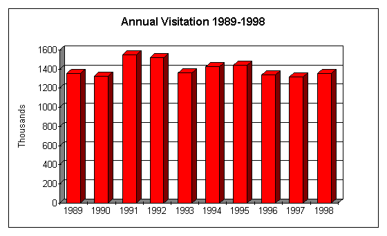
The following information regarding park visitors and use patterns is derived from various park surveys and documents (including the GMP), discussions with park staff, and data collected and maintained by the National Park Service Socio-Economic Services Division (WASO) in Denver. Also see Appendix B for a summary of social survey information relevant to MORA. The following chart shows total annual recreation visits for the ten-year period of 1989-1998:
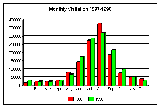
This graph illustrates total monthly visitation during 1997 and 1998:
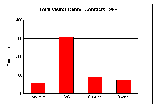
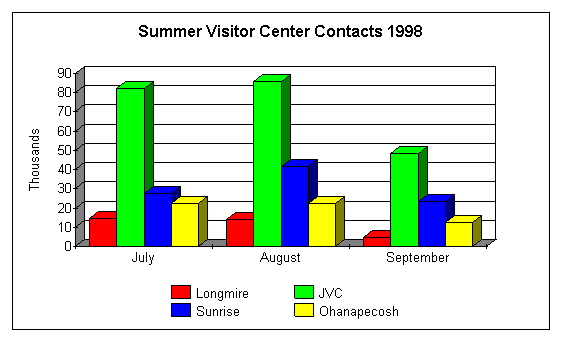
The next two charts compare visitation at the four main visitor centers in the park. The first graph shows the total annual visitation at the centers. However, since only the Longmire Visitor Center is open all year (the others operating seasonally or on a part-time basis for portions of the year) the second graph illustrates the monthly visitation only from July through September, when all the centers are open.
The FY-99 Annual Interpretive Program Report lists the following numbers of visitor contacts:
Personal Services
Visitor Centers/Contact Stations 698,002
Informal Interpretation 38,220
Formal Interpretation 43,386
Junior Ranger Programs 2,525
Special Events 2,825
Non-Personal Services
Park Produced Publications 1,500,000
Audio-Visual/Electronic Media 56,214
Outreach Services
Community Programs 62,665
Park Web Site 2,771,760
The following statements are excerpted from visitor experience section of the MORA GMP and were derived from the various visitor surveys and studies listed in Appendix B:
IMPLEMENTATION STRATEGIES
The following is a description of program and media recommendations designed to further define, support, and implement the mission, goals, themes, and objectives of the interpretive program for Mount Rainier National Park. The discussion of each program or media proposal identifies its purpose, special considerations, and sometimes suggests means of presentation. It is important to remember that the latter are only suggestions, and should not in any way limit the creativity that is essential during the media or program design processes. On the other hand, most proposals will be specific enough to define parameters in which these creative energies can flow.
A number of proposals address the American Indian peoples (past and present) who have strong associations with the mountain and the surrounding area. It is essential that the park initiate and maintain a continuous dialogue with area tribes regarding the planning, design, and production of theme-related interpretive media and programs.
Information and Orientation
Pre-Arrival
General and trip planning information regarding MORA will continue to be provided through traditional means by answering regular mail and telephone requests. Due to the volume of phone calls, the park will continue to utilize an automated routing menu; however, ways to make the system more efficient and convenient in directing callers need to be explored.
Responses to written requests will continue to be tailored to individuals. The park, however, will also continue to have standard packets available for more common requests for camping and lodging information, and for students seeking park information for school assignments. Supplies of education materials (i.e. the Educator's Guide and CD-ROM) also will be maintained for answering teacher and group leader information requests. In addition, the park will provide much of this information on its web site, where people can read and download specific materials. Responses to phone and written requests also will include mention of the web site as a source of additional information. This practice could result in reduced costs of printing, paper, and staff time in handling information requests.
The park will continue to maintain its excellent web site which contains a wealth of general, trip planning, resource, educational, and theme-related interpretive material, as well as links to many related sites. Staff will continue to work at improving the site and incorporating additional topics such as elements of the education programs, the potential sister park association with Japan's Mt. Fuji, virtual tours of special exhibits, geo-hazards, etc.
As elements of the GMP are implemented, modifications to the trip planning elements of the web site could inform prospective visitors of new facilities, closed areas, and alternative destinations in the area. Strengthening the links with other regional agencies, communities, and visitor attractions will help people make more informed decisions, distribute park use during peak periods, and enhance the overall visitor experiences.
On a regional scale, MORA information would continue to be placed in area tourism offices, visitor/information centers, agency offices, and at major attractions and lodging facilities. A key publication in this regard is the park newspaper The Tahoma News. Unlike the official park folder, which is often in limited supply, the newspaper can be more widely distributed and can focus more on changeable information. Future editions of The Tahoma News also could include a good map of the region, and partnerships with outside entities could help pay for a separate page on area services and attractions. Participating partners also could explore the enhancement of existing literature and/or the development of a new multi-agency brochure outlining where visitors can get more information about MORA, other regional resources and attractions, lodging, etc.
There is a wealth of regional, national, and international literature (including web sites) describing and/or marketing MORA. Sometimes those preparing this information consult park staff, or at least request periodic reviews. To the extent possible, the park needs to ensure that printed and electronic tourism literature promoting the park is accurate, adequate, appropriate, and up-to-date. This, and many of the other activities/proposals in this section could be performed by a park public information office-a position which does not currently exist.
Improved highway signing is needed to direct visitors to the park from major area highways. The park also needs to work closely with others in the region to provide good maps and to consistently mark good routes for reaching the park. The GMP also stresses the importance of using signs and area information centers to alert visitors to any peak time park closures and alternative travel options.
On-Arrival
The GMP proposes a staffed visitor contact facility outside each of the five main highway entrances to the park. Each will provide basic trip planning information and orientation to park resources, themes, and programs, and advise visitors of any area closures. Visitors will be able to find information on where to hike or camp, what to see for various lengths of visits, where to park, etc. During peak visitation periods, these centers will serve a most important function of suggesting alternative activities and destinations when some park areas are full. Even at non-peak times, visitors will benefit from a better knowledge of area resources and attractions, especially those that reinforce park/regional themes and illustrate the linkages between the park and the surrounding region.
Safety information on geo-hazards, avalanche danger, visibility, weather conditions, necessary equipment, pets, roadway precautions, climbing, etc. also would be available. Since some information is seasonal, displays will be designed to highlight the most prevalent topics. Media and messages designed to affect visitor actions should be based on the best and current research available regarding influencing human behavior. Media planners and designers also need to be aware of multi-cultural differences and attitudes toward resources. Informational wayside exhibits will be placed outside each facility to serve after-hours visitors as well as people who arrive when the buildings are closed for the season.
While visitors cannot be required to stop at these facilities, they will be strongly encouraged to do so. This will be accomplished through highway signing, area marketing strategies, and via low-watt radio broadcasts, called Traveler Information Stations (TIS). The TIS broadcasts will provide capsule information regarding fees, hours of operation, permits, etc. The broadcasts, which can be easily updated, also will advise travelers that they can save time at the entrance stations and in-park facilities by paying the entrance fee and getting wilderness use permits before they enter the park. Signs will be needed to inform people to tune their car radios to the appropriate frequency.
The exact locations and sizes of these external facilities are beyond the scope of this plan. Likewise, whether the facilities are operated solely by the NPS or through partnership arrangements, are operational decisions that need to be negotiated with any interested participants. At this writing, the Packwood and Naches contact centers have the greatest potential to function as joint NPS/USFS facilities, utilizing existing structures. The cooperating association already has limited sales outlets in these two buildings.
A permanent, larger, and accessible visitor contact center in or near Wilkeson will replace the current railroad caboose. As with Packwood and Naches, this facility could be housed in a new or existing structure, and it could be operated in partnership with others. In addition to the general information/orientation functions outlined above, wilderness permitting will continue to be a primary function of the Wilkeson facility.
The proposed visitor contact center near the northeast entrance along Route 410 would serve primarily as a shuttle bus staging facility for visitors going to Sunrise. When the vehicle carrying capacity for Sunrise is reached, visitors will be directed to this staging area where they will park their cars and ride a shuttle to Sunrise. Other information and orientation functions also will be necessary for visitors entering the park, or seeking alternative destinations or activities.
Since most MORA visitors arrive through the Nisqually entrance, the new visitor center proposed along Route 706 will become the park's main visitor contact facility outside par boundaries. Unlike most of the other external visitor contact centers, the Nisqually facility will be open all year, and will provide information and orientation appropriate to the season. The interpretive components of this and the other external visitor contact centers will be discussed in the next section.
Radio and telephone communication among the various visitor contact centers and entrance stations will be extremely important. Each facility will need to be alerted of any area closures, so that visitors can be efficiently directed to alternative locations. In addition, improved communications and partnerships among other tourist destinations and attractions in the region will help ensure the production and distribution of accurate and current information to visitors. Center phone numbers also could be listed on the park web site.
Each of the external contact centers and entrance stations will provide visitors with copies of the official park folder, the park newspaper, and other pertinent literature. At the contact centers, space will be needed for storing maps, folders, and other free literature. To avoid waste, each center would have a changeable display case near the information desk containing samples of various site bulletins and other free literature. Text would inform visitors that copies of the folders are available on request.
This plan recommends the establishment of a multi-agency partnership to function as a clearinghouse for regional information. This group of area information providers would assess regional information needs and evaluate materials which are successful and unsuccessful in meeting visitor needs.
The official park folder will need to be revised as elements of the GMP are implemented. The maps should not only help visitors tour the park, but also show the primary routes for reaching the park from major highways. Also, the park newspaper would be redesigned primarily to cover changing subjects and perhaps include a good map of the region.
Except perhaps for the Nisqually Visitor Center, most of the contact centers likely will have limited space for informational and interpretive media. Where possible, portable, or even temporary exhibits could be adapted to small spaces, rotated through the seasons, or used to highlight special events, themes, resource issues, and recent incidents.
Inside the park, the directional signing program should be evaluated to ensure that it is standardized throughout. The signing and approaches to the major facilities, trailheads, overlooks, etc. will clearly indicate where visitors are to turn, park, and locate facilities. Signs also should clearly inform visitors of the need for backcountry permits and direct people to the WIC's before they get to the trailheads.
Interpretation
The following describes interpretive recommendations for the various facilities and venues throughout the park. This is a site-based narrative directed primarily toward linking the media and program proposals to the visitor experience. As a cross-reference, Appendix D displays a chart which illustrates how the media recommendations are tied to the primary interpretive themes. Visitors generally experience a park, not by exploring each individual theme, but by traveling to the different sites; however, the chart serves as a check to see where and how each theme is addressed at the various sites.
The planning team was fortunate to have Carolyn Driedger, a hydrologist with the US Geological Survey, as a participant. Carolyn has developed a list of theme-related geology exhibit and wayside exhibit concepts/ideas for MORA. Some of these ideas are related below, but the entire list is found in Appendix C.
Nisqually Visitor Center
The GMP has recommended a new visitor center along the Nisqually entrance road. The pre-design and design phases of the building's development will address the various functions or "program" for the facility. From an interpretive perspective, the structure will need to contain the following:
Rest rooms for employees
Rest rooms for the public with interior/exterior entrances
Cooperating association sales outlet/bookstore, including separate office for handling money
Auditorium with seating to accommodate one or more bus groups (150 seat minimum)
Meeting room for employees, teacher workshops, etc.
Office and work space for staff
Storage for free and sales publications, and interpretive demonstration materials
Possible topics for some of the information/orientation exhibits were discussed in the previous section. The topographic relief map, however, has potential for conveying interpretive messages in addition to serving an obvious orientation function. A new relief model is needed, as a number of changes have occurred since the old ones were made. New relief maps could include interactive elements that would illustrate and interpret various natural and geologic changes over time-i.e. glaciation, lahars, eruptions, and aspects of ecological communities and succession.
A key objective for the interpretive exhibits (some perhaps including audiovisual components) will be to introduce visitors to each of the park's primary interpretive themes. The center's exhibits also will present regional topics such as the fragmented forest, air quality, Indian presence, and the rivers originating from the mountain--all topics that transcend the park boundary. Since some peak season visitors may be unable to gain access to a number of the most popular areas in the park, the Nisqually Visitor Center may be their only opportunity to learn about some of the significant resources and their related themes. The presentation of elements of regional themes/topics will help visitors place the park in a regional context, and also encourage people to visit other sites outside the park boundary.
During the media planning and design phase, decisions must be made regarding a feature/site based approach or a topic/theme treatment for the exhibits. The former would help people plan their visit and get an introduction to the various sites, the latter might better interpret processes and place the resources in a broader context. A blend of the two approaches may prove to be the best solution, something that a good planning/design firm will be able to accomplish.
The new visitor center's location at a low elevation will likely result in it being open year round. Its location affords a safer place for displaying museum objects and perhaps interpreting the overall history of the park. The exhibits could be developed to offer visitors a journey up the mountain and a journey through history. Through these journeys visitors also would discover how the mountain has become a cultural and spiritual icon to past and present peoples.
To retain the interest of the park's many repeat visitors, changeable exhibits focusing on resource issues, recent natural or geologic activities, and special events may encourage regional visitors to stop each time they come to the park.
By the time this new visitor center is built, the new park audiovisual program may have been produced. In developing the treatment for the new film, consideration should be given to a program that will capitalize on the concepts of a journey through history and a journey up the mountain. Film/video can be very effective in bringing the past to life. This medium also is good for presenting concepts such as geologic time, and illustrating processes like glaciation, lahars, and other phenomena. If the Nisqually Visitor Center is completed before a new film is produced, the park should explore the potential with PBS of getting "Rainier: The Mountain" documentary film edited for use as a temporary park audiovisual program.
A projection booth would be included in the theater design to enable the showing of slide, film, and video programs. The theater also could be used in the evenings for ranger talks and for various community meetings/gatherings.
As a year round operation, the Nisqually Visitor Center will probably become the cooperating association's major sales outlet. While most people are expected to use the facility on their way into the park, others will stop on their way out. The bookstore should carry a full line of theme-related items, including driving tours (on tape and/or CD).
Depending on the location of the new visitor center, ranger-guided interpretive talks and tours may be possible. For example, if the facility is located near the river, personal services interpretive programs could utilize this resource to link the park with Puget Sound-illustrating how the mountain influences the entire region.
Route 410 Shuttle Staging Center
This new facility will function primarily as a shuttle bus staging center for trips to Sunrise. The building also will serve as an external information/orientation and wilderness use permitting center for visitor entering the park along this corridor.
The building program will need to include the following functions:
Staffed information/permitting/entrance fee collection desk
Lobby/exhibit area
Audiovisual alcove, possibly without seating
Rest rooms for staff and public
Storage for free and sales publications
Offices for staff (including cooperating association) and for handling monies
At this time, it is uncertain whether this facility will be open at non-peak times when the buses are not required. If not, then there may be little need for much interpretive media, since visitors riding the buses will be able to experience the facilities at Sunrise. In any event, interpretive exhibits (possibly portable or rotating displays) at the staging center would provide a basic introduction to the park themes. Interpretive media also would include a small video alcove for showing the park film.
A small cooperating association sales outlet also would be provided. Sales items would focus primarily on themes related to the Sunrise area and include a few parkwide publications.
It is uncertain whether any form of interpretation will be offered on the buses. The preferred option would be to hire paid and/or volunteer staff to ride the buses and provide on-board narration and answer questions. Another option would utilize recorded interpretive messages that could be activated by the bus drivers at designated locations. This latter option may require acoustical treatments to the buses to ensure good sound quality.
Packwood and Naches Visitor Contact Centers
As stated in the information/orientation section, the Packwood and Naches visitor contact centers will most likely utilize existing USFS facilities and possibly be operated through partnership agreements. The small size of the potential existing structures will limit the amount of media development.
Where feasible, the interior spaces (building program) would include the following:
Staffed information/permitting/cooperating association sales desk
Lobby/exhibit area
Audiovisual alcove, possibly without seating
Cooperation association sales area
Office for staff (including cooperating association) and for handling monies
Storage for free and sales literature
While the emphasis will be on information and orientation to the park and the region, exhibits would be developed to introduce each of the park's interpretive themes, and place appropriate themes into a regional context. The exhibits will probably be of a simple design- primarily text and graphic panels, utilizing few, if any, original objects. Space permitting, a small video alcove would be designed for showing the park film.
Both of the facilities already have a small cooperating association sales area, and it is recommended that these would continue.
To further strengthen the park/region interpretive links, as well as the inter-agency partnerships, the participants could explore the development of a series of roadside pullouts and wayside exhibits along these entry corridors. These elements could become part of a park/region wayside exhibit proposal.
Wilkeson Visitor Contact Center
The new Wilkeson visitor contact center will serve visitors (mostly local and regional people) entering the park from the northwest. The primary function of the facility will be to provide information/orientation and to issue wilderness use permits. In addition to informing visitors about safety, trails, and what to see along the drive, etc., interpretive exhibits would provide an introduction to each of the park's primary interpretive themes (especially those related to the rainforest and old growth stands) and critical issues.
With the volume of wilderness users, this will be a good opportunity to place special emphasis on the wilderness theme. Also, since there is a high volume of repeat visitation, the development of a series of changing portable exhibits on topics such as air quality, geo-hazards, NPS/park history, etc. will encourage visitors to make repeated stops. Improved signage will redirect lost visitors headed to Paradise, and will identify the center as the only place to obtain wilderness permits.
The significance of the Carbon River Road as part of the parks National Historic Landmark District would be mentioned in the contact center media, but the main interpretive sites would be along the road itself. This would be addressed through part of a parkwide wayside exhibit proposal, and a potential self-guiding tour publication. Wayside exhibit locations will need to be carefully considered, as the area is prone to vandalism and sections of the road often become flooded.
The GMP calls for the removal of the Ipsut campground and amphitheater; however, through a proposed boundary change (also recommended in the GMP) there is potential to build a new campground and amphitheater at a location currently outside the park. If this happens, it will be possible to reinstitute ranger-led evening programs in this sector of the park.
Longmire
The Longmire Museum will continue to be the primary interpretive facility at this site. Longmire is a centerpiece for the National Historic Landmark District, and for interpreting the history of the park. The current exhibits would be redone to better reflect the totality of the human presence, the significance of the park's built environment, and people and events associated directly with Longmire..
Any new interpretive media would respect the historic integrity of the site. This would exclude the use of modern, high-tech elements such as interactive computer stations. The park does have some original film footage showing the construction of some of the infrastructure that is now part of the historic landmark designation, as well as scenes of early park visitors, etc. In addition, some oral history recordings exist of people associated with the early days of the park. These could become exciting elements of the new exhibits, which could be developed in ways to compliment the site's historic character. Additional historic photos could be simply displayed via captioned photo albums for visitors to examine.
While the primary interpretive emphasis would be on the history of the park, Longmire also is an excellent place to relate aspects of the ecology of nearby mineral springs and old growth forests. Self-guiding interpretive trails in the area would focus on both the history and ecology themes, perhaps emphasizing how one has affected the other in this area.
The proposed education center for Longmire is discussed in a later section; however, part of this center is to include a room that will be open to all visitors. The interpretive media and programs in this space will be aimed toward children and families. The content would reinforce elements of the themes presented elsewhere at Longmire, but would stress interactive and hands-on activities. The space would generally be open for visitors to explore on their own, but the option would be available for staff-led activities.
Personal services interpretive programs would continue to include ranger-guided walks and talks, but this could be expanded to include costumed and living history programs and demonstrations. Special activities utilizing "old timers" will continue to help people visualize Mount Rainier National Park in an earlier time.
Many people who visited the park in the early days, along with early employees and others who were directly or indirectly involved in building the park's infrastructure are still living in the region. Several American Indian tribes in the region also have a rich oral tradition which includes strong connections with the mountain. All these people have important stories to tell and represent a knowledge base that is slowly disappearing. To help capture elements of this rich heritage, the park needs to increase its efforts (perhaps through partnership agreements with area colleges) in conducting and transcribing oral and/or video history interviews.
Once the new Nisqually Visitor Center is built, there may be less need for a full scale wilderness information center (WIC) at Longmire. If this becomes the case, the park staff will explore the potential of using the room for some of the personal services interpretive programs in the summer, and as a place to wait for the road to open in the winter. For the winter, a series of text/graphic panels could provide information regarding snow safety, avalanche danger, geo-hazards, and possibly include some interpretation of the building itself. Access to the building will need to be improved, and maintenance issues (i.e. snow removal) addressed.
The current exhibits in the historic Longmire gas station are adequate and could be retained. As an alternative, a historic furnishing report (possibly developed through Harpers Ferry Center) would determine the feasibility of adding furnishing elements to the current exhibit, or possibly furnishing the whole interior. If determined feasible, then a historic furnishing plan and treatment could be commissioned to acquire the proper objects and place them in the room.
Another historic furnishing option to explore is the creation of a 1920's to 1930's ranger quarters in one of the historic cabins. A separate historic furnishings report would assist in determining the feasibility of this option.
The lodge also is an excellent place to provide some interpretive/informational services. The park should ensure that concession employees and guests have access to accurate and current information about the park, the Longmire area in particular, and the interpretive program activity schedule. Staffs should work together in discussing the interpretive value and/or content of interior wall decorations, information about the historic buildings and landmark district, and reading materials in rooms and food service areas. The lodge area also should be considered in developing the parkwide wayside exhibit proposal and plan.
Paradise
Paradise will remain one of the most popular destinations in the park; however, to preserve a quality visitor experience, the GMP has recommended carrying capacity limits for the site. When implemented, some park visitors may be unable to stop here on peak days, but those who do gain access will find less congestion and an atmosphere more conducive to appreciating park resources and values.
The GMP also recommends that the Jackson Visitor Center (JVC) be removed, and replaced with a smaller structure in closer proximity to the lodge. Since this action may take a number of years to complete, this section includes interim recommendations for improving the interpretive media and programs in the existing structure, and proposals for a new facility.
Interpretive media and programs at Paradise will focus primarily on sub-alpine ecology, the site's spectacular meadows, and on the prominent geologic resources and processes. Besides exhibits and audiovisual media inside the visitor center, in summer people will be encouraged to get outside and experience the "real thing."
Visitors will gain an understanding and appreciation of the complexity and diversity in the meadows, their fragility, and how these meadows differ from those in other parts of the park (i.e. Sunrise). People also will learn about past and current research and management strategies designed to protect these areas. Since the meadows lie under the snow for much of the year, interpretive media may provide the only way for many visitors to see them. Conversely, summer visitors may find it hard to imagine the vast amount of snow covering the meadows in the winter. Photos of winter use at Paradise would not only show how dramatically different the area is, but might also encourage visitors to experience the park during the non-peak seasons.
Interpretation of the geology theme will stress the features and processes tied directly to the resources at Paradise. Special emphasis will be placed on some of the key geologic research projects and what has been learned from them. New visitor center exhibits would explain the nature of the Nisqually glacier: how it is formed, how it moves, why it is changing in size, how it shapes the landscape, what new research has revealed, etc. People would understand the conflicting dichotomy of fire and ice on the mountain and would appreciate the nature of existing geo-hazards of this active volcano. Visitors would learn why most of the rocks at MORA come from the same source but look very different. The concept of inverted topography and new understandings of lava flows also could be interpreted (see Appendix C).
The understanding of some of the geologic concepts and processes (i.e. glaciation, volcanism, lahars, etc.) could be enhanced through such things as time-lapse photography, film/video, interactive models, computer simulations, and before/after graphics. Research instrumentation can attract visitor attention, provided they are adequately interpreted. If they just sit there, or if they do something that is not explained, the instruments will have little meaning to most visitors. Consideration should be given to including some of these technologies in the new exhibits. This would include a new film, perhaps emphasizing the geology, but also showing how the geologic forces influence the ecosystem.
In this regard, a theater will be an important component of the new Paradise visitor center. While some AV elements can effectively be incorporated into exhibits, other complex and/or sequential stories and processes (as indicated above) are best told in a theater setting through a dedicated AV program. The program also would enable visitors to see the Paradise area at different times of year, and when the mountain is obscured.
Outside, there is an excellent opportunity to develop a self-guiding interpretive trail to follow the movement of the Nisqually glacier. Wayside exhibits or a publication supplemented with wayside exhibits could include photos and illustrations showing how far the glacier has moved and how it has changed the landscape. If a self-guiding brochure is developed, it should be prominently displayed in the visitor center, the lodge, and perhaps in a dispenser at the trailhead. Wayside exhibits will provide additional information at key locations, and also will offer some interpretation for visitors who walk the trail without a brochure.
The wayside exhibit plan also would address the interpretation of the various historic structures at Paradise.
Paradise is an excellent place to view and interpret climbing and winter recreation at MORA. Wayside exhibits on climbing and winter use would be developed at prominent viewpoints. A wayside exhibit outside the climbing permit station at Paradise would identify the building's function and provide some climbing safety information.
In the visitor center, the many aspects of climbing, including techniques, evolution of equipment, videos, etc. are easy to exhibit, and can be supported by many objects in the park's collection. However, caution is needed to ensure that the interpretation of climbing on MORA does not overshadow coverage of more important themes.
If the JVC is to remain in operation for several more years, it will be advantageous to the park, and in the best interests of providing a quality visitor experience, to replace the current exhibits and audiovisual program in the building. Technical assistance for exhibit planning and design is available through the Harpers Ferry Center, which also can help set up contracts for fabrication.
The following short-term changes to the JVC are recommended (some include alternatives):
Upgrade the bookstore (i.e. insulation and heat) so it can be opened in the winter,
Remove all of the exhibits on the second level; retain the ecology exhibit on the third level.
Work with the Washington State Museum for the loan and/or acquisition of the MORA exhibit in Tacoma. (Note: Only portions of this exhibit may be appropriate for use at the JVC.)
On the observation desk level, develop low-cost interior wayside exhibits on climbing, winter use, and other topics related to features in the viewshed. Some of the Tacoma exhibits also could be used here.
Current peak use visitation statistics indicate that the new visitor center should be capable of accommodating between 300-500 people at one time.
The building program also would include the following information/interpretive components:
Lobby with room to accommodate bus groups, organize guided tours, and provide information/orientation exhibits, including a topographic relief map
Warming/viewing area which could contain some exhibit displays
Cooperating association sales outlet/bookstore, including separate office for handling money [The bookstore will need to be locked at night when the auditorium is used for evening programs.]
Office, first aid station, meeting room, and work space for staff [In the peak season, there are 7-9 employees on duty per day.]
Storage for free and sales publications, interpretive demonstration materials, and winter storage for wayside exhibits
Storage/fitting area near an entrance for snowshoe tours
Evening programs would move from the lodge to the new visitor center auditorium. This will alleviate current conflicts with competing activities in the lodge, and provide a better atmosphere for evening interpretive programs. Building design will consider the need to secure other parts of the center when the auditorium is used for evening programs.
The interpretive staff at Paradise also will continue to offer a variety of year round personal services programs. In summer, roving interpretation has the advantage of placing staff where most people concentrate and in sensitive resource areas. As individual talents and budgets vary from one season to the next, the number and types of activities will change from year to year. Personal services programs also will continue to take advantage of on-going research, and to utilize the special knowledge and talents of researchers, partners, and staff in other park operations.
The Paradise Inn also is an excellent place to provide some interpretive/informational services. The park should ensure that concession employees and guests have access to accurate and current information about the park, the Paradise area in particular, and the interpretive program activity schedule. Staffs should work together in discussing the interpretive value and/or content of interior wall decorations, information about the historic buildings and landmark district, and reading materials in rooms and food service areas. The lodge area also should be considered in developing the parkwide wayside exhibit proposal and plan.
Sunrise/White River
Sunrise is a popular destination during the few months in the summer when it is open. With the implementation of the GMP, Sunrise also will have carrying capacity limits, which are designed to maintain a high quality, less congested visitor experience. Since vehicular limits will be reached before the actual visitor limits are exceeded, a shuttle bus will be provided from the Route 410 staging area outside the north entrance of the park. Interpretive options for the bus tours are described in the Route 410 Shuttle Staging Center section.
Sunrise can't be beat for the sheer drama of its geologic story. Although portions of the geology theme will be interpreted at Paradise (with special emphasis on current research) and at key locations along park roads, Sunrise will capitalize on the historical geology of the mountain as it relates to what visitors see at the site. Other key theme-related interpretive topics at Sunrise include sub-alpine ecology, and the past and present significance of the site to American Indian tribes in the region.
Visitors will gain an understanding and appreciation of the complexity and diversity in the sub-alpine meadows, their fragility, and how these meadows differ from those in other parts of the park (i.e. Paradise). People also will learn about past and current research and management strategies designed to protect the meadows.
Visitors will understand and appreciate how various Indian tribes have used the site for hunting and gathering, their relations with the NPS, and their spiritual ties with the mountain which continue to the present. Emphasis will be placed on how the archeological record and oral and written histories are enriching our knowledge and understanding of these native peoples and their interactions with other cultures and the land.
Sunrise is also a good place to observe climbers on the mountain and to learn about the history of this popular activity at MORA.
To present elements of these themes/stories, this plan proposes a redesign of the interior of the Sunrise Visitor Center. This redesign will not make changes to the historic fabric, but will require the following functional interpretive areas:
Lobby with room to accommodate bus groups, organize guided tours, and provide information/orientation exhibits, possibly including a topographic relief map
Large stone fireplace used for drying out and warming up
Storage for interpretive props and demonstration materials
Since no changes or additions are proposed for the building, planners/designers will need to work with the existing space. Other constraints include the fact that the building is closed and unheated for much of the year. This may preclude the use of some types of objects, or at least necessitate the removal of some items at the end of each season. Care will be needed in considering the use of any high tech media, which also may need to be removed at the end of each season. Electronic devises may be subjected to power surges; and, anything chosen will need to blend well with the rustic setting.
There is no room in the visitor center for an audiovisual theater; however, audiovisual elements could be incorporated into some of the exhibits. A small AV alcove also could be considered. AV, for example, can be an excellent method for illustrating geologic processes. The use of audio will need to be carefully considered in such a small space.
A separate planning effort may be needed to solve some of the storage and office space deficiencies. Improvements to the existing telephone system also may require separate study.
Sunrise will be an important component of the parkwide wayside exhibit proposal and plan, which will assess all existing wayside exhibits and make recommendations for new ones. Wayside exhibits also will be considered in providing supplementary interpretation along self-guiding trails. One such trail would give visitors a tour of the historic structures at Sunrise.
The Mount Fremont Fire Lookout is a popular destination for visitors to Sunrise, and it is the location of an advertised "wildlife watch" interpretive program. A historic furnishing study would assess the potential for re-furnishing the tower or at least adding some furnishing elements to the space. The use of reproduction pieces also would be explored. Allowing visitors or staff to use reproduced fire detection instruments would add an interactive dimension to the interpretive experience. A wayside exhibit would interpret the tower, even when it is not open.
The White River Patrol Cabin also has potential for interpretation. Here visitors will learn about the history of park trails (including the development of the Wonderland Trail), and the role of these ranger cabins in backcountry, fire, and poaching patrols. A historic furnishing study and plan could be implemented to give visitors the feel of what it was like to live here. The use of removable barriers would allow the furnishings to be viewed when the cabin was unstaffed. However, since the cabin is in a high geo-hazard zone, only reproduction items would be recommended.
Another option would be to continue with the series of text/graphic panels to interpret the building, possibly including an exterior wayside exhibit. In either scenario, the media treatment could be supplemented with personal services interpretive programs and demonstrations. Accessibility standards can be met through slight modifications to the side entrance. The cabin is also difficult to find, parking is a major problem, and directional signs would be needed to get visitors to the site. The park also will explore the potential of a self-guiding interpretive trail from the White River parking area to the river.
The WIC, located at the White River Ranger Station, would continue its primary function as a wilderness use permitting center. To supplement the information provided at the site, some interpretive displays and an audio-visual program could focus on geo-hazards, wilderness safety and ethics, and climbing. Due to the small space, the displays would consist mainly of text/graphic panels. The audiovisual program might be shown as a computer power point presentation, which could be tailored and/or duplicated for different areas of the park.
The interpretive staff at Sunrise will continue to offer a variety of personal services programs. In summer, roving interpretation has the advantage of placing staff where most people concentrate and in sensitive resource areas. As individual talents and budgets vary from one season to the next, the number and types of activities will change from year to year. Personal services programs also will continue to take advantage of on-going research, and to utilize the special knowledge and talents of researchers, partners, and staff in other park operations.
Partnerships with area tribes will be critical in interpreting the American Indian connections to the Sunrise area. Official tribal consultation will be necessary in the development of interpretive media and programs. Some of the stories may be told best through personal services programs or demonstrations presented by members of individual tribes. Also, the various tribes would be consulted regarding native names (and their meanings) for various features in the park. These names could be used in addition to their Euro-American counterparts on a number of the wayside exhibits and other interpretive media throughout the park.
Ohanapecosh
Except for the development of new site-based thematic media at the visitor center, the GMP proposes no changes to Ohanapecosh. It was felt that the establishment of the external visitor contact center along the road to Packwood and elsewhere would obviate the need for expanding the Ohanapecosh facilities inside the park. However, since the site does have its own unique resources, visitors will continue to be attracted, and parking (which at times is a problem now) may prove to be inadequate to meet future demand. The parking problem needs to be addressed, but not at the expense of the forest setting.
Forest and river ecology has been, and will continue to be the primary interpretive focus at Ohanapecosh. The significance of the nearby hot springs would be interpreted, not only from the context of their relation to the ecology theme (including the fact that they have no connection to Mount Rainier's volcanic heat), but also from the historic human perspective. The current booklet could be replaced with wayside exhibits.
The connections of regional American Indian peoples to this site and to the mountain would be interpreted. Nearby archeology, and the historic use of the area for gathering pealed cedar bark are but two examples of these strong American Indian associations. Visitors could appreciate how the bark was pealed and woven into baskets used to gather berries and other materials higher on the mountain.
The interior of the Ohanapecosh Visitor Center will be redesigned and equipped with new media. Functional interpretive spaces will include:
Lobby with room to accommodate bus groups and provide information/orientation exhibits, including a topographic relief map
Exhibit areas for permanent and changeable interpretive displays, possibly including some audiovisual elements
Cooperating association sales outlet/bookstore, including separate office for handling money
Storage for sales and free literature
Storage for interpretive props and demonstration materials
The building does not have a theater; however, a small video alcove could be incorporated into the new design. A new audiovisual program would be developed for the site, highlighting elements of the prominent site themes. Another option (primarily for visitors arriving through the western entrances) would be to show the new parkwide AV program here. Other audiovisual elements (with or without sound) could be integrated with some of the exhibits. This could include footage of cedar bark pealing and weaving and/or historical scenes of the hot springs.
A new or revised topographic relief map, similar to the one proposed for the Nisqually Visitor Center is proposed for Ohanapecosh. Since the mountain cannot be seem from here, the map will help orient visitors and illustrate the physical and ecological connections with other areas of the park and region.
Ohanapecosh would be included in a parkwide wayside exhibit proposal and plan. Wayside exhibits would be considered for use on self-guiding interpretive trails, where they would provide the main messages or perhaps supplement information in a trail publication. A new trail is proposed from the ranger station to the visitor center.
Except for upgrading the audiovisual equipment, only minor changes are proposed for the amphitheater, including some leveling and repairing of the blacktop walkways, and replacing some benches. This facility will continue to be used for evening programs and for various daytime interpretive activities.
Personal services activities are an integral part of the interpretive program at Ohanapecosh, and contribute greatly to the family atmosphere of the site. In addition to the variety of activities currently provided, the park would explore involving the associated American Indian tribes in scheduling interpretive programs and cultural demonstrations. The establishment of partnerships in this area would contribute greatly to enhancing visitor understanding of the past and continued connection of Indian peoples to the park. The tribes also would be actively involved in the planning and design of the overall interpretive media and programs for the site.
Education Program
This plan recommends a significant expansion of the parks formal education programs for multiple age groups. There is great potential to foster stronger relationships with the education community throughout the region, which includes one of the largest metropolitan areas of the western United States. Computer technology also allows a worldwide audience to participate in elements of park education programs, even though many students may never have the opportunity to visit in person.
To be successful, an expanded education program at MORA will require additional staff (see staffing section). The new education coordinator will be responsible for setting up a steering or advisory committee with area educators and other park staff to produce a formal education plan for MORA. Once established, the coordinator will be responsible for managing both the on- and off-site components of the program. The coordinator also will be heavily involved in the planning, design, and development of an in-park education facility. The former Macy Dormitory at Longmire has been recommended.
The development of curriculum-based activities will form the core of the education program. These activities will be produced in partnership with area educators, who are most knowledgeable of school curricula and workload requirements. Other agencies, such as the US Geological Survey and the US Forest Service, along with some private non-profit entities, have educational programs and materials which focus on the park and park resources, and should be enlisted as partners in coordinating efforts. In addition, the park should work closely with the NPS regional education specialist, who will be assisting multiple parks, and serving as an urban (Seattle-Tacoma area) education coordinator.
The partnership arrangement would seek to make use of existing education programs and materials. Some excellent materials are already available, and it would be foolish to duplicate efforts unnecessarily.
Other major responsibilities for the education coordinator and steering/advisory committee will include:
Encouraging school field trips to the park.
Planning and conducting teacher workshops
Overcoming the cost of transportation for bringing school groups to the park
Providing on- and off-site resource materials to educators in an efficient, cost-effective manner
Some initial actions will include reaching out to the local communities and re-establishing contacts with educational groups. A resources guide to the various programs and advice on planning a field trip to MORA would be developed. Various strategies, such as grant applications, could explore cost-sharing alternatives for providing transportation.
Incentives to attend teacher workshops would be explored. Workshops could be scheduled as an alternative activity to in-service teacher workdays. Annual park passes could be provided to participating teachers, so they could visit the park on their own or with their families. Workshop attendees could receive free curriculum guides and other lesson-planning materials. Training could be designed in partnership with area universities to provide academic credit to participants.
Elements of the education program would be available through the park web page. Some materials would be free and could be downloaded by anyone. Other materials could be advertised for sale through the cooperating association. Although web materials can reach worldwide audiences, one special audience would be school groups in Japan as an education link between the potential sister parks (MORA and Mt. Fuji).
The teacher workshops could utilize sister agencies in the region and some of the retired NPS interpreters who still live in the area. In addition, park staff from other operating divisions (i.e. resource management, protection, and maintenance) could be given the tools to assist occasionally with on- and off-site programs. Some of these people currently give talks to schools, and creating closer ties to the education program would be an advantage to all. Eventually, additional staff would be needed to coordinate the on- and off-site programs.
As stated earlier, the park has initiated plans to convert the old Macy Dormitory at Longmire into an education center. The facility will have two basic components: a reserved classroom/laboratory section for school and adult groups, and a separate room open to the public. The latter was introduced earlier in the Longmire section. While the reserved section would be used only for scheduled classes, the public room would become a focal point for the parks junior ranger program. In this room, most of the interpretive emphasis would be placed on themes and stories associated with Longmire, but others would deal with parkwide topics.
Although the junior ranger program is an informal interpretive activity, it definitely constitutes an important part of the overall education program at MORA. Focused on children, the program is designed to foster stewardship and to show that kids can make a difference. The park will strive to develop junior ranger program elements at each major interpretive facility in the park.
Many of the activities in both the public and reserved sections of the Longmire Education Center, as well as in the other park visitor centers, would utilize interactive modules, and emphasize kids teaching kids (in person or recorded). How a volcano works, safety in geo-hazard areas, people of the past, natures communities at MORA, what park people do, and how to become a park ranger are some of the specific topics which could be addressed in exciting and interactive ways. The center would be an excellent place to show videos such as "Lost but Found, Safe and Sound." All presentations will relate to park themes.
Besides the programs for youth, this plan recommends the establishment of a Mount Rainier Institute for adults. One reason the previous program failed was the lack of a place in the park to hold classes. The Longmire Education Center would provide a meeting place, with lodging available nearby during non-peak times. If the logistics can be worked out and an adequate education staff provided, the wealth of subject matter expertise in the region could produce a highly viable institute program.
If the proposed land exchange near the Carbon River entrance is achieved, any existing buildings may have potential for use in the park's education, institute, and/or research programs. Such a facility could better serve the communities in this sector of the park.
Roads and Trails
Since driving the scenic roads and hiking are two of the most popular visitor activities at MORA, it is important that information and interpretive messages associated with these experiences meet visitor needs and relate appropriate theme elements. Many of the most significant resources, including numerous geological features, are found along the roadways and trails, and, therefore, are the most logical places for interpretation.
The parkwide wayside exhibit proposal and plan will assess all existing wayside exhibits along park roads, trails, and trailheads, and make recommendations for new ones. In some cases the same exhibit panel may be replicated at different sites. Areas deserving particular attention include Ricksecker Point, Narada Falls, Reflection Lake, Box Canyon, Mowich Lake, Tipsoo Lake, and the Carbon River Road. The plan also would address the need for portable and/or short-term wayside exhibits to interpret sudden or unpredictable events such as avalanches, lahars, etc.
All major trailheads should have an informational wayside exhibit to give safety information, length and difficulty of trails, appropriate rules and regulations, and descriptions of the main features/destinations en-route. Some of the wayside exhibits may have maps showing the route of a trail, including any major intersections, and possibly a bulletin case for posting seasonal or other changeable information. Self-guiding interpretive trailheads also may have a trail guide brochure dispenser nearby or attached to the wayside exhibit during summer.
Wayside exhibits at roadside overlooks would be easy for visitors to locate, and would interpret prominent features in the landscape/viewshed. The interpretive staff, in consultation with the park sign shop and others, needs to explore ways to alert visitors of up-coming overlooks, especially those that have interpretive messages.
Campgrounds and Amphitheaters
Informational wayside exhibits would be located at each of the park's primary campgrounds. The number, style, and placement will be determined by the parkwide wayside exhibit proposal and plan. The campground exhibits will probably include bulletin cases for posting seasonal and other changeable information. This would provide places for posting interpretive activity schedules and announcements of special events.
A new amphitheater is recommended for Cougar Rock and for the proposed new campground along Carbon River Road (to replace Ipsut Creek). The Ohanapecosh amphitheater is in good shape, but all of these facilities need upgraded sound equipment. Rehab work also is needed at the White River amphitheater, but it will not include adaptations for electricity or a sound system.
Publications
Numerous references to various publications have been made throughout the document. Some have included:
Making periodic revisions to the official park folder as elements of the GMP are implemented.
Standardizing the format and design of park site bulletins, and developing panels to display them.
Considering the park web site as an electronic publication which can integrate various site bulletins, education programs elements, activity schedules, bibliographies, etc.
Producing some of the key publications, especially those related to safety issues, in multiple languages.
New site bulletins that address primary theme elements, especially geology, geo-hazards, glaciers, American Indians of the region, etc.
Park-related literature provided in concession food service areas and lodges. These include things such as table tents and place mats in restaurants, and packets of material placed in individual rooms.
Specific sales publication needs identified during this planning process include:
Items regarding the various American Indian tribes that have strong connections to the mountain.
Publications, similar to the new "100 Years at Longmire Village," which relate aspects of the park's human history and the significance of its architecture.
An official park handbook (as part of the NPS series)
Items, such as CD-ROM's, on wilderness use and appreciation, historic photos, and other items in the park's collection, etc.
Special Populations
Provisions will be made to accommodate the needs of special populations who visit Mount Rainier National Park. Special populations are identified as those with sight, hearing, learning, and mobility impairments; visitors who do not speak English; and the elderly and young children.
Accommodations will be made for access to the sites, as well as to most of the interpretive media. Guidelines and regulations are available to assist staff and media/facility designers. Generally, these accommodations will benefit all visitors.
Public Law 90-480, the Architectural Barriers Act, and the Americans with Disabilities Act of 1990 establish standards for physical access. Any new or re-designed facilities constructed, as a matter of course, will be designed for accessibility for physically disabled visitors and employees.
All new interpretive media will conform to National Park Service, June 1996 Programmatic Accessibility Guidelines for Interpretive Media (see Appendix A).
Staffing and Training
[The staffing section will be prepared by the park staff.]
[The following addresses training.]
In addition to on-going training in interpretive skills and knowledge of the resources, park interpreters and others who deal with the visiting public need to keep abreast of current research, technologies, programs, and activities, not only as they relate to park resources, but also regarding visitor studies, interpretive media, education, etc. By working across operational division lines, effective and efficient ways to alert and/or involve staff in new or on-going projects and innovations can be explored.
The park also would explore opportunities to offer interpretive skills and resource training to non-NPS folks who engage in interpretive, education, and information/orientation activities. Training could be offered through scheduled courses, workshops, etc. Potential trainees could include area educators, volunteers, interagency staff, retired interpreters in the region, tribal members, and others in the region and local communities who offer interpretive and informational services.
Products and Initial Priorities
Products
The following is a summary list of new interpretive media, programs, and/or facilities that will contain such media at the various units of Mount Rainier National Park. While the list does identify new, redesigned, or restored structures, the focus is primarily on interpretive media. The list does not include things such as mechanical systems, security systems, rest rooms, offices, storage areas, workrooms, parking lots, and road/trail development. These items, plus all new/restored structures and furnishings (e.g. seating, information desks, and sales displays) should be included in Denver Service Center, Regional Office, cooperating association, or contractor planning, design, and construction specifications.
The following products are organized by site or major program area:
[Also consult the Staffing section for personnel needs.]
Wayside Exhibit Proposal and Plan
Update official park folder (on-going)
Upgrade park web site (on-going)
Upgrade park newspaper (on-going)
MORA official handbook
New topographic relief maps/models for visitor centers (3-4)
Portable (theme-based) exhibits for external visitor centers and off-site use (4-5 sets)
New site bulletins on geology, research, old growth forests, geo-hazards, etc.
Interpretive text/graphic panels for historic wilderness cabins
Site bulletin display cases for all visitor contact centers
Special geo-hazard publications and signs
Evaluate directional sign system for reaching the park (external)
Evaluate directional sign system inside the park
Re-initiate oral history program
CD-ROM's on wilderness use, historic photos, etc.
Establish partnerships with educators, American Indian tribes, former NPS employees, colleges and universities, and others who will help implement elements of this long-range interpretive plan
Re-establish the MORA Institute
Conduct parkwide publications review/evaluation
Develop parkwide and site-specific publications priorities and implementation programs
Plan, design, and construct new facility
New information/orientation and theme-based exhibits (some with audiovisual and/or interactive
components)
New site specific audiovisual program (new overall introductory program moves to Nisqually)
New information desk
New cooperating association sales area
Plan, design, and construct new facility (or adaptively use an existing structure)
Explore partnership arrangements for center operations
New information/orientation and theme-based exhibits (some with audiovisual and/or interactive components)
New cooperating association sales area
Self-guiding trail (with booklet and/or wayside exhibits)
Explore partnership arrangements for center location operations
Plan, design and adaptively use an existing structure
New information/orientation and theme-based exhibits (some with audiovisual and/or interactive components)
New or re-instituted cooperating association sales area
Explore partnership arrangements for center location operations
Plan, design and adaptively use an existing structure
New information/orientation and theme-based exhibits (some with audiovisual and/or interactive components)
New or re-instituted cooperating association sales area
Plan, design, and construct new facility
New information/orientation and theme-based exhibits (some with audiovisual and/or interactive components)
New cooperating association sales area
New exhibits for museum (some possibly utilizing historic audiovisual elements)
Historic furnishing study options for gas station
Historic furnishing study options for period ranger cabin
New exhibits (possibly including new topographic relief map) for the WIC
Interior re-design of the WIC for winter use
Design living history/costumed interpretation programs & acquire period clothing and props
Exhibits (some with AV components) and furnishings for education center (Macy Dormitory)
Exhibits (some with AV components) and furnishings for family/junior ranger room (Macy Dormitory)
Enlarge amphitheater and upgrade sound system
New temporary exhibits (all levels)
New audiovisual program (overall park introduction)
Move/improve design of information desk and lobby
Adapt bookstore for winter use
Plan, design, and construct new facility
New information/orientation and theme-based exhibits (some with audiovisual and/or interactive components)
New site specific audiovisual program (new overall introductory program moves to Nisqually)
New information desk
New cooperating association sales area
Self-guiding trail (with booklet and/or wayside exhibits)
New information/orientation exhibits
New information/orientation and theme-based exhibits (some with audiovisual and/or interactive components)
New cooperating association sales area
Self-guiding trail (with booklet and/or wayside exhibits)
Explore potential for American Indian interpretive activities and demonstrations
New exhibits and/or historic furnishings
New information/orientation exhibits
New exhibits and/or historic furnishings
Upgrade amphitheater (not to include electrical or sound system)
New information/orientation and theme-based exhibits (some with audiovisual and/or interactive components)
New cooperating association sales area
Self-guiding trail (with booklet and/or wayside exhibits)
Explore potential for American Indian interpretive activities and demonstrations
Upgrade amphitheater and sound system
Initial Priorities
Implementing some of the items from the extensive products and staffing recommendations lists will require independent planning efforts and other actions over the next 5-10 years. Other action items can by implemented immediately, within existing funds and staffing levels. In future years, the priority setting process will be reflected in the Annual Implementation Plan component of MORA's Comprehensive Interpretive Plan.
The following is a prioritization of the initial actions (divided into larger and smaller cost categories) for which funds are on-hand or obtainable within the next 1-2 years:
Larger Cost Priorities
Jon Jarvis, Superintendent
Dave Uberuaga, Deputy Superintendent
Maria Gillett, Chief of Interpretation and Education
Sheri Forbes, Assistant Chief of Interpretation and Education
Carol Sperling, West District Interpreter
Ted Stout, East District Interpreter
Lisa Okazaki, Longmire/Carbon River Area Interpreter
Alisa Lynch, Interpretive Specialist
Anne Doherty, Education Specialist
Kale Bowling, Centennial Assistant, Interpretation
Craig Strong, Cultural Resources Specialist
Victoria Jacobson, Historical Architect
Deborah Osterberg, Museum Curator
Barbara Samora, Biologist
Ralph Bell, Sign Shop
Debbie Brenchley, Park Ranger, Protection
Cindy Mish, Nisqually Entrance Station
Deanne Adams, Team Leader, Visitor Services and Interpretation
Diane Converse, Administrative Director, NWIA
Sarah Mettler, MORA Branch Manager, NWIA
Rusty Sproatt, Managing Director, GSI
Pam Newlein, GSI
Jen Benn, Executive Director, Washington's National Park Fund
Karina Jensen, Office Manager, RMI
Thelma Gilmur, Tahoma Audubon and Tahoma Mountaineers
Carolyn Driedger, Hydrologist, USGS
Bonnie Lippitt, Mount St. Helens NVM
Chris Maun, Nisqually River Education Project
Anne Delph, Destination Packwood Association
Tanna Osterhaus, Ashford Community and Ashford Valley Business Association
Dale Thompson, Wildlife Artist and former MORA Chief of Interpretation (retired)
Ronald Warfield, former MORA Assistant Chief of Interpretation (retired)
Loren Lane, former MORA Interpretive and Education Specialist (retired)
Larry Beal, Project Manager, Denver Service Center
Anne Tubiolo, Audiovisual Producer/Director
David McLean, Senior Exhibit Designer
Paul Lee, Interpretive Planner
APPENDICIES
Appendix A: Programmatic Accessibility Guidelines for Interpretive Media
[Note: This will be added at the final printing.]
Appendix B: Summary of Social Survey Information at MORA
[The following document was written by Mark E. Vande Kamp and Darryll R. Johnson: Field Station for Protected Areas Research, College of Forest Resources, University of Washington. Although written with regard to the MORA-GMP, the results of these studies will have many implications for the interpretive program.]
From the early stages in the process of formulating the Mount Rainier National Park General Management Plan (MORA GMP) it has been emphasized that social survey data are relevant to many aspects of NPS planning. One way to think of the contributions made by social survey data is to review the questions that such data can address. Seven general questions that were initially identified as important to the MORA GMP were:
A variety of surveys were conducted at MORA as a means of addressing the seven questions listed above. The surveys are described below, with special attention focused on the questions addressed by each survey.
Visitor Distribution Survey (VDS)
The VDS survey took place over three four-day periods in 1995: July 8-11; August 12-15; and August 26-29. Observers at a wide variety of sites (including trails, parking lots, and facilities) made counts of visitors or vehicles between 10:00 a.m. and 4:00 p.m. on each day. A total of 36 sites were observed in July, and 72 sites were observed in the August sessions.
The VDS was intended to address questions concerning where visitors were concentrated in MORA, and the more specific follow-up question of how many visitors are present. Analysis of the data has provided descriptions of the average weekday and weekend use that was observed at all sites for the 10:00 a.m. to 4:00 p.m. period. These descriptions provide information about the total numbers of visitors present, the time at which visitor density is highest, and the length of time that such peak use commonly persists.
In addition to a basic description of the observed use levels, the VDS data were also used to estimate a variety of information for the selected sites. This information included: total and peak use for sunny and cloudy weekdays; total and peak use for sunny and cloudy weekends; and use level of trails when parking lots were filled to their design capacity.
This last set of estimates concerning trail use and parking lots levels illustrates how descriptive data can inform management decisions. By comparing the full parking lot estimates to the sunny weekend peak estimates, the MORA planning team can assess the likely impact of limiting visitor parking to the designed capacity. The VDS data could also be used in many other informative ways throughout the GMP process and in the on-going management of MORA. The data constitute a useful baseline measure, more extensive than that commonly available to park managers.
Visitor Experience Surveys
Five visitor surveys were conducted between July 5 and September 6, 1995 as a means of addressing the remaining five questions listed above. These surveys were designed to focus on management zones that had been proposed by the planning team. They describe characteristics, behavior, and opinions of visitors present during the peak visitation season. Such data are likely to be quite different during the winter or shoulder seasons.
As indicated by their name, these surveys focused on the developed facilities in MORA. Nine sites were selected and on-site surveys were conducted of visitors at those facilities. At Longmire, visitors were contacted at the gift shop, museum, and restaurant; at the Paradise Inn, visitors were contacted at the gift shop and snack bar; and at the Jackson Visitor Center, visitors were contacted at the bookstore, gift shop, restaurant, and in the lobby. Between 170 and 300 visitors were surveyed at each of the sites.
The Facilities Surveys were intended to assess three of the seven questions listed above:
The Gate Survey focused on the proposed Motorized Sightseeing Zone. About 940 mail surveys were returned by visitors who were contacted at the Nisqually and Stevens Canyon entrances. The White River entrance was omitted for a number of reasons including: a) funding and staff considerations; b) because a survey had recently been conducted at that gate; and, c) because most MORA visitors (at least 65%) enter via the Nisqually or Stevens Canyon gates. The Carbon River entrance was also omitted, primarily because bridge construction had a large impact on visitation in that area during the survey period.
The Gate Survey of visitors to the Nisqually/Stevens Canyon corridor was intended to address the last six of the seven questions listed above:
As indicated by the name, this survey focused on the proposed Sensitive Resource Zone. About 720 mail surveys were returned by visitors who were contacted at Nisqually Vista, Dead Horse Trail, Skyline Trail, Pebble Creek, and Burroughs Mt. Trail.
The Sensitive Resource Survey of hikers at five frontcountry trails was intended to address five of the seven questions listed above:
As indicated by the name, this survey focused on the proposed Wilderness Trail Zone. About 580 mail surveys were returned by visitors who were contacted at Comet Falls, Summerland, Mt. Fremont Lookout, and Glacier Basin.
The Wilderness Trail Survey of hikers at four wilderness trails was intended to address four of the seven questions listed above:
This survey focused on all the proposed Wilderness Zones. About 290 mail surveys were returned by visitors who were contacted when requesting overnight backcountry permits at Longmire and Paradise.
The Wilderness Overnight Survey was intended to address four of the seven questions listed above for trail zones and off-trail areas in wilderness:
In the summer of 1993, prior to the formation of the GMP planning team and the adoption of the VERP planning process, three visitor surveys were conducted to collect information pertinent to the MORA GMP. These surveys, like the VES surveys discussed above, can also be described in relation to the questions they address. They describe characteristics, behavior, and opinions of visitors present during the peak visitation season. Such data are likely to be quite different during the winter or shoulder seasons.
Spray Park Visitor Survey (SPVS). This survey focused on visitors to Spray Park, a popular wilderness day-hiking destination in the northwest corner of MORA. Visitors were contacted at the entrance to Spray Park (about three miles from the trailhead) and were asked to complete an on-site questionnaire. About 850 visitors completed the on-site questionnaire and about 580 mail questionnaires were returned.
The SPVS was intended to address five of the seven questions listed above:
The MLVS was intended to address four of the seven questions listed above:
The WRS survey focused on visitors who were most responsible for planning their party's trip to MORA, because one of the primary purposes of the survey was to investigate the ways in which information might be used to alter visitor patterns. Thus the survey focused on the persons most responsible for making visitation decisions. The WRS survey was intended to address four of the seven questions listed above:
Other Visitor Surveys And Reports That Provide Information Pertinent To The MORA GMP
Several visitor surveys conducted prior to 1993 were not conducted as part of the MORA GMP, but nevertheless collected information pertinent to the planning process. These surveys can also be described in relation to the questions they address. In addition, one report based on survey data is also pertinent.
1990 Mount Rainier General Visitor Survey (1990 GVS). This survey contacted a sample representative of all MORA visitors across all seasons of the year. About 1,580 mail surveys were returned by contacted visitors.
The 1990 GVS represents a baseline against which we can compare the results of the more recent MORA visitor surveys in order to assess changes in visitor characteristics and activities. It also represents the only survey data describing winter visitors to MORA. The 1990 GVS was intended to address four of the seven questions listed above:
Study Of Visitor Attitudes Toward Initiation Of A Visitor Transportation System At Mount Rainier National Park. This survey contacted a sample of summer MORA visitors. About 988 mail surveys were returned by visitors contacted in the summers of 1988 and 1989.
The transportation survey was intended to ascertain the opinions of park visitors toward the establishment of various transportation system alternatives at MORA. Unlike the surveys discussed above, the transportation survey was focused on this specific issue and did not address the general questions concerning visitors to MORA. Still, the potential use of a transportation system and discussion of such use in the MORA GMP make the transportation survey a pertinent source of information.
Projected Consumption Of Outdoor Recreation Activities Within Mount Rainier National Park And Surrounding Region. This report projects future demand for recreation activities including developed area camping, primitive camping, sightseeing, picnicking, attending visitor centers and museums, wildlife observation, outdoor photography, day hiking, and bicycling at MORA. As with any projections, these are based on assumptions that may or may not prove to be correct. Nonetheless, judicious use of such projected demands for recreational activities can improve the likelihood that the planning process will produce a successful MORA GMP.
Appendix C: Exhibit/Wayside Concepts - Geology
The following are excerpts from Carolyn Driedger's report/comments subsequent to the LRIP workshop. As with other media proposals in this document, the suggested means of presentation should not be regarded as firm recommendations.
Here are some specific geologic concepts that could be expanded upon for future exhibits at park visitor centers. (The list is not comprehensive.)
Mount Rainier is an ACTIVE volcano--Emphasize evidence for the visitor--active steam vents, seismicity, and recent eruptions.
Mount Rainier's continuing geologic story--how the same processes that built and shaped the mountain continue, and pose as hazards today. Perhaps a multi-media "assembling of the mountain" display is appropriate.
Mount Rainier is like a layer cake of lava flows and rock rubble--show examples for visitors to observe.
Mount Rainier geologic processes have been observed far back in human history--travel from past to future with use of native oral traditions, historical accounts, and prospects for the future.
Rock erupted during a single eruption can appear very different for some very understandable reasons. (Examples: rock columns, glass, crystals, "rust", and rocks that crack open like pages of an opened book.)
Many ash layers within the park originated on Mount Rainier's sister volcanoes. Visitors can gain an understanding of the frequency and recentness of volcanic activity by observing the ash layers in exhibits and on trails throughout the park.
Mount Rainier is a world-class example of a volcano that produces abundant landslides and lahars. Make some comparisons with other volcanoes in Cascades and elsewhere.
Focus on glacier behavior, dynamics, roles, and histories. Mount Rainier's glaciers are alive and well. Variation is to be expected. Glacial geology provides a record of environmental change. Glaciers are an integral part of the alpine ecosystem.
Fire and ice interactions:
When will Mount Rainier erupt?
When was the last eruption?
How will we know when Mount Rainier is becoming restless?
How old is Mount Rainier?
Is Mount St. Helens connected to Mount Rainier underground?
Do earthquakes cause eruptions?
Is lava hot enough to burn?
How tall was Mount Rainier in previous times?
Sunrise
Opportunities for trail signs exist at Emmons Vista, throughout Yakima Park, Sunrise Point, and at turnouts along the road to Sunrise and at White River Campground.
Possible geologic stories include:
Longmire
(upgrade existing wayside exhibits)
Mowich Lake/Ipsut Creek Area
Appendix D: Table of Media/Program/Theme Relationships
| Theme Topic | Inside Facilities/Media
(exhibits, AV, film, etc.) |
Outside Media
(wayside/trailside exhibits) |
Personal Services | At Home/Take Home Media |
| Geology
-mountain as a volcano -active processes -global connections -geo-hazards -geologic time/human time -glacial processes -glaciers shaping the mountain -forces of fire and ice -volcano monitoring, research, prediction -beauty |
-Paradise Visitor Center-
film and exhibits (modern view)
-Sunrise Visitor Center- film and exhibits showing processes (traditional view) -Nisqually Visitor Center- film and exhibits -Wilkeson Contact Center- exhibits on glaciers & river action -White River Ranger Station- geology and you (safety) -Paradise, Sunrise, or Nisqually- interactive relief model -All to make Pacific Rim & Cascade Range connections |
-Paradise Glacier- self-guiding
trail
-Parkwide- geology "discovery" wayside exhibits along park roads (part of park-wide wayside exhibit proposal/plan. -Sunrise-self-guiding geology trail booklets/waysides -Carbon River- booklet and/or waysides on erosive power of the river |
-All topics have relevance to
personal services activities.
-Geology caravan/auto tour (option for fee interpretation) -Field Institute and/or seminars -Geologist-in-Parks program |
-Sale of park video(s)
-Site bulletin on the mountain as a volcano -USGS publications on geo-hazards -Geo-hazard publications for lodge guests, campers, employees, & residents -Sales publications on the general geology stories for different age & interest levels -Official park handbook -Expand/improve web site to include experiential tours. -Park newspaper- more on current research & other interpretive topics. |
| Theme Topic | Inside Facilities/Media
(exhibits, AV, film, etc.) |
Outside Media
(wayside/trailside exhibits) |
Personal Services | At Home/Take Home Media |
| Ecology
-recreational impacts -air pollution -effects of volcano -endangered species & habitat -exterior influences that transcend boundaries -adaptations to habitats & ecosystem -park as outdoor laboratory -research & natural resource management issues -global climate changes -ecosystem interaction components -vanishing old growth -loss of species -fragmentation & logging effects -similarities with other places -reservoir of genetic diversity -basic ecological processes |
-Ohanapecosh Visitor Center-
forest ecology exhibits
-Sunrise Visitor Center- meadow & sub-alpine ecology media (#2 theme) -Paradise Visitor Center- meadow & sub-alpine ecology media (#1 theme). Provide interpretation for the air quality instrument. Show seasonal changes. -Wilkeson Contact Center- rainforest exhibits -Nisqually Visitor Center- exhibits on general topics, including those which cross the boundary. -Interactive devices to prompt interest in scientific research and monitoring techniques. |
-Longmire- trail booklets,
etc. (not waysides) to interpret old growth forest ecology.
-Ohanapecosh- waysides and other media on old growth. -Re-assess value of "Don't be a Bigfoot" signs. -Warning signs about social trails in meadows (i.e. Tipsoo). |
-Programs on old growth at Longmire
& Ohanapecosh
-Utilize maintenance crews in the field to give information to visitors. -Meadow rovers give information on recreational impacts -Uniformed staff presence in the field -Field institute programs to show research & park as a laboratory -Cross training and sharing information among resource management staff and interpreters -Utilize resource management staff in interpretive programs -Science symposium -Ecology as a major component of the education programs. |
-Publications on old growth
-Retain "Meadow Stomper" buttons. -"State of the Park" insert to park newspaper -Publication series on current park research -Web site could include detailed and/or real-time monitoring data and updates from researchers -Ecology concepts for junior ranger program -Emphasize "what you can do" along with information on ecological problems and issues. |
| Theme Topic | Inside Facilities/Media
(exhibits, AV, film, etc.) |
Outside Media
(wayside/trailside exhibits) |
Personal Services | At Home/Take Home Media |
| Wilderness
-Wilderness Act -the MORA wilderness experience -natural quiet -clear skies -sustainable design -cultural resources in wilderness: fire lookouts, trails, cabins -wilderness etiquette and values -changing attitudes toward wilderness -legal/tangible & experiential/ intangible concepts of wilderness -nature bats last -intrinsic value of wilderness -spiritual, aesthetic, and solitude aspects of wilderness -complexities of wilderness management -carrying capacities and cumulative effects of people in wilderness areas |
-Longmire WIC- wilderness
& climbing policies & safety. Also, connect wilderness & historic
views by showing how wilderness management has changed over time.
-Paradise Old Station- climbing policies & safety -White River Patrol Cabin- trails & early ranger patrols -Mt. Fremont Lookout- historic role in fire management/suppression -Nisqually Visitor Center- present multiple points of view toward wilderness -All WIC's to inform about wilderness etiquette and proper behavior -AV program which shares multiple personal relations, perspectives & experiences in wilderness. -Smaller relief models, possible with interactive elements -Utilize the words of well-known writers & poets who speak to wilderness -wilderness interactive computer |
-Avoid littering the wilderness
with signs
-Trailhead signs (informational waysides) -Retain "your are entering wilderness" signs. -Small interpretive panels on backcountry cabins to explain their historic role in protecting park resources. |
-Experiential programs on the
intangible aspects of wilderness
-Programs on wilderness for children -Encourage dialog on wilderness (i.e. a comment wall). -Provide visitors with opportunities for self -expression on wilderness. -Present factual programs on wilderness issues. -Forum/mock town hall meeting on wilderness. -Evening programs on wilderness: changing views toward, tangible/intangible elements, philosophy, etc. -Living history programs and the use of historic quotes. -Education & outreach programs provide introduction to wilderness & foundation for values development. |
-Use web site & CD-ROM's as
outreach to wilderness seekers and to armchair wilderness advocates.
-Publication of the history of legislation and changing attitudes toward wilderness. |
| Theme Topic | Inside Facilities/Media
(exhibits, AV, film, etc.) |
Outside Media
(wayside/trailside exhibits) |
Personal Services | At Home/Take Home Media |
| Human History
-the mountain as an icon -living connections with the past for American Indian tribes -park as a mecca for recreation -the irony of preservation and development -MORA as a good example of early park planning -rustic architecture -management successes and failures -duality of the NPS mission -learning about stewardship -establishment of the park -establishment of the National Historic Landmark District -early settlers, explorers, and mountain challengers |
-Nisqually Visitor Center-
the mountain as an icon and journey through time
-Lodges- present elements of NPS story and mission -Longmire- exhibits to focus primarily on human stories. -Film to focus on people's relations with the mountain (possible use of excerpts from recent PBS program). -CD-ROM database on historical/cultural collections, archives, film & photos. -Exhibits/AV program utilizing above plus oral histories -Testimonials of personal ties to the mountain. -Historic buildings are expected and designed to be subliminal- not noticed. And it works! |
-Sunrise area- waysides
interpreting significance of historic structures as result of early park
planning. Also exhibits on history of climbing.
-Carbon area- wayside exhibits on mining, the NHLD, and history of the road. -Paradise area- waysides on history of historic buildings and on recreational history at the site. -Narada Falls- (or Christine Falls) waysides on the landscape arch. |
-Longmire area- living
history, costumed interpretation, Nisqually Indian demonstrations/ programs.
Could include costumed roving on Trail of Shadows or programs in the community
building, WIC (in winter), and lodge. Tours of historic Longmire.
-Paradise- Nisqually Indian demonstrations/programs. -Sunrise area- Yakama Indian demonstrations/programs. -Ohanapecosh area- Cowlitz Indian demonstrations/ programs. -Carbon/Mowich area- Puyallup & Muchleshoot Indian demonstrations/ programs. -Utilize guest speakers with personal stories from the past. -Evening programs "Voices & Visions" -Create interpretive activities (i.e. nature guiding or caravan tours) that have the feel of programs from the old days (1930's). |
-More publications, such as the
recent "100 Years at Longmire Village", on all aspects of the parks human
history.
-Special effort to increase items related to Indian tribes related to the mountain.
|