Kate Franklin & Nicolle Gilsdorf
Elementary Social Studies
Date: 1/25/05
Week four
Title: Analyzing the Perspective of Maps
Based on: Segall, A. (2003) Maps as Stories about the World. Social Studies and the Young Learner 16(1). National Council for the Social Studies,
p. 21-25.
Grade: 6th
Key Concepts:
· What do maps, globes, and charts teach us about the world?
· Different versions of historical accounts
· Investigating history from multiple sources.
· Perspectives on the importance of different countries
Goals: to understand that there are many versions of maps and compare them to learn more about world perspectives
Objectives: After a teacher lead discussion and exploration about two maps, students will be able to identify and compare the major differences between two broad categories of world map projections.
EALRs:
- Social Studies: 1.1 Inquiry and Information Skills
Searches for relevant information
Evaluates information
· Geography 1.1.2 Use maps to gather and interpret geographic information
Learning Targets: Knowledge, Skills, Dispositions
Time: 50 minute lesson
Assumptions: Students have worked in pairs and are familiar with group work.
Materials:
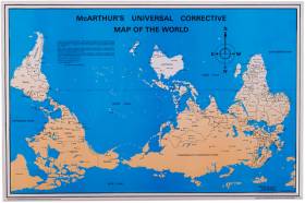
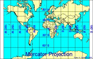
Mercator maps x 15
McArthur maps x 15
White board or chalk board
Paper and pencils
Set Up: Space for pairs to meet, agenda on the board
Accommodations:
-students who struggle with images will have previewed the maps
-graphic organizer
-color coding directions on board
Pre Assessment:
- 5 minutes. Please get out a pencil and a piece of paper and individually write down your response to the question on the board. “What does a map tell us” or “what do you know about maps”.
- 5 min. Have students share what they thought of and write responses on the board for future reference.
Activity:
- 2 minutes. Give context for lesson:” Today we are going to explore maps. Every map tells a story and today we are going to tease out the story about these maps.
- 8-10 minutes. Pair students up and give each group a Mercator (the traditional map with Europe and America in the center) map and a McArthur Map (a corrected map with Australia at the top and center). Write the two names of the board for students to refer to. Ask students to compare the two maps.
- 3 minutes. Stop the class and handout the graphic organizer. Ask students to list the difference and the similarities of the two maps.
- 8-10 minutes. Allow students time to explore the maps and respond to the question, what are the maps trying to tell us?
- 15 minutes. Ask students to share their answers. Tell them, “Now we are going to have a discussion on what you learned”.
- Be sure that some of the main differences are brought out.
- What is in the center (those countries are perceived as more powerful) of each map. (Who produces the map tends to see themselves in the center)
- What is the McArthur map is trying to “correct”? (the Eurocentric position)
- Why might it be preferred to people living in Australia? (they are in the center and seen as powerful)
- How would an American feel if the McArthur map was the one used in the classroom?
- What message does each of the maps send it’s readers about who is important in the world?
- How does your new understanding of maps affect what you think?
- So, what does this mean for cartographers when they are trying to draw a map? What is accurate information? From whose perspective should they draw the map from? What are they telling the viewer about their idea of the world? What does this mean for when you write a report?
Assessment:
Journal prompt: Respond to the following questions:
· What do maps, globes, and charts teach us about the world?
· How did your first understanding about the map change? How so? (They can refer to board if necessary).
Extensions to Learning:
- Discrepant Event could be having a nontraditional map up in the class
- Have a discussion about gravity- is there an up and down in space?
- Explore who makes maps and why. How are mapmakers affected by their cultural filter?
- Doing a math exercise that compares the square mileage of continents to their actual coverage on the map.
Resources
http://www.flourish.org/upsidedownmap/
The upsidedown map page. Shows entertaining variety of maps and related resources about viewing the world from different perspectives.
eol.jsc.nasa.gov/sseop/clickmap
Photos from space from satellites
http://www.colorado.edu/geography/gcraft/notes/mapproj/
Map projections
http://www.lib.utexas.edu/maps/
good selection of contemporary and historical maps
Mercator |
McArthur |
|
Similarities |
||
Differences |
||