METHODS - Evapotranspiration
The Bowen Ratio Instrumentation System (Campbell Scientific, Inc. Micrologger
model 21X) measures the amount of water vapor lost to the atmosphere as
a function of time and also provides continuous monitoring of temperature,
solar radiation, rainfall, relative humidity, and wind speed and direction.
Using these measurements, the potential ET can be calculated using the
Penman-Monteith equation and the Bowen-ratio method. The system used is
the 21X Micrologger from Campbell Scientific, Inc. This system uses a
cooled mirror hygrometer for sampling air volumes from two separate heights
(1m and 2m) to determine water vapor pressure gradient.
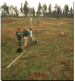
Two thermocouples measure the temperature gradient. A net radiometer measures net solar radiation, and averaging thermocouples and heat flux plates placed in the ground measure soil heat fluxes. Wind speed anemometers and rain gauges provide other necessary meteorological measurements. The Bowen Ratio Instrumentation System was placed at 46053'50.22"N and 123004'44.1"W and monitored from April 2001 through June 2001 for this study. The system was placed on the prairie on a level intermound space 200 meters from the nearest forested area as shown in Figure 6. All data was downloaded to a storage unit, converted by Microsoft Excel, for use as Mathcad data. Daily computations were done in Mathcad and then put back into Microsoft Excel for analysis. Rainfall was recorded for correlation of ET results. The system was inspected weekly for damage and routine maintenance was performed to ensure precision of measurements. Routine maintenance included replacing the filters in the air intakes, cleaning radiometer domes, and verifying the dew point hydgrometer.
A soil sample was taken each week to calculate flux of energy going into the soil. The samples were taken from the side of different mounds, each within 50 feet of the instrument. Care was taken not to disturb the area anymore than necessary to get the sample. Core samples were 4.3 cm in diameter, taken approximately 10 cm in depth. Large stones and organic matter were avoided. The sample was weighed, dried at 105 degrees C and reweighed to determine bulk density and moisture content.