GPS Basics
Gail A. Fullerton
Environmental Analysis
The Evergreen State College
What is GPS
GPS stands for Global Positioning System. The Global Positioning System is a group of U.S. Department of Defense satellites. These satellites constantly orbit the earth transmitting radio signals. These radio signals contain coded information that allows GPS receivers to determine where they are.
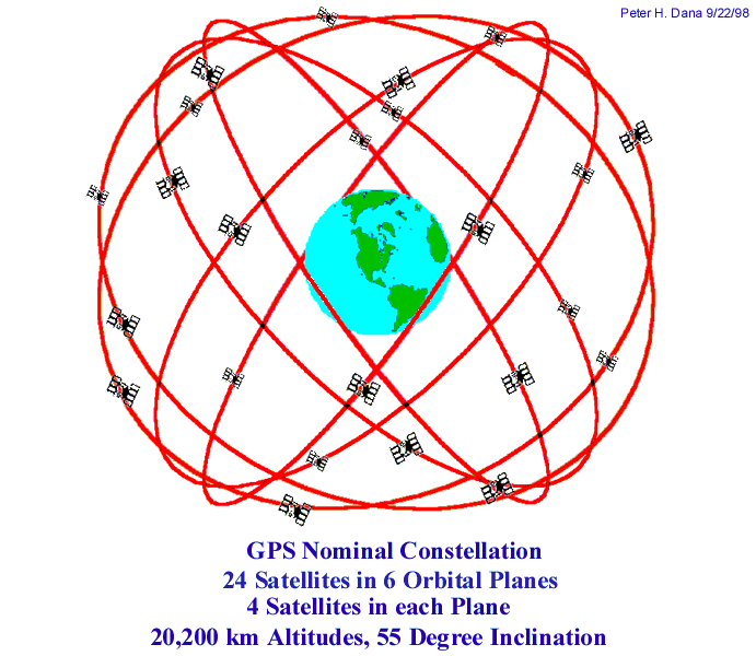
GPS consists of three segments: space, control and user. The space segment is the satellites themselves.
The control segment monitors the satellites and transmits update information to them.
The user segment is anyone using a GPS receiver.
How GPS works
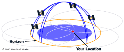
GPS operates on the principal of trilateration. By knowing the distance from where you are, to three points (in different directions) you can determine your location.
With GPS we are dealing with the same principal but using time instead of distance. This works because time multiplied by velocity equals distance. The Velocity of satellite signals is that of the radio wave – 186,000 meters per second. (the speed of light) By knowing the location of four satellites and the time that the signal left each satellite a GPS receiver can determine its location. The fourth satellite is needed to calibrate the clock in the receiver to the clock in the satellite. (More detailed information is available at several websites. See references below.)
Uses
of GPS
GPS can be used for navigation. GPS is used to collect locations of features to be included in maps. Points collected by GPS can be used to georeference arial photos. If you are using GIS, GPS gives you a way to get spatial information about areas you are working in into a GIS coverage.
Types
of Data
GPS receivers record data in one of three ways: points, lines and areas.
All GPS receivers collect points. Some receivers can collect many points and average them a specified time interval. This result of this averaging is more accurate data.
Some receivers can also collect line and area data.
Line data is recorded as a series of points linked by a line which joins the points in the order they are recorded. Line data would be used to record a road, fence or stream bank.
Area data is recorded in the same way as point data, but the last point collected is automatically joined to the first to form an area. Area could be used to record a lakeshore, or the a pasture.
Sources
of Error
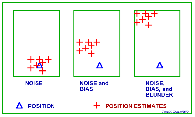
Noise errors are caused by, noise in the radio signal that the satellite receives and noise within the receiver.
Bias errors are the result of:
satellite clock errors uncorrected by the control segment,
Orbital or Ephemeris errors: The ephemeris contains predictions of satellite position at a given time.
Ionospheric and Trophospheric delays: The satellite signal slows as it passes through the atmosphere. The system uses a built in model that calculates the average but not the exact amount of delay)
Multipath errors: Multipath errors occur when the signal from one or more satellites is reflected from a surface near the receiver. The receiver can mistake the reflected signal for the direct signal from the satellite. (The surface might be a building a mountain or a tree)
Geometric Dilution of Precision (GDOP): These errors result when the satellites monitored by the GPS receiver are too close together.
GDOP has several components:
PDOP: Position Dilution of Precision (3-D)
HDOP: Horizontal Dilution of Precision (Latitude, Longitude)
VDOP: Vertical Dilution of Precision (Height)
TDOP: Time dilution of Precision (Time)
Blunder errors:
Control segment mistakes
User mistakes such as using an incorrect geodetic datum
Receiver errors from hardware or software failure.
Degree of Error by source
Satellite clock errors: 1 meter
Ephemeris data errors: 1 meter
Trophospheric delays: 1 meter.
Unmodeled ionosphere delays: 10 meters.
Multipath: 0.5 meters.
User mistakes: 1 to > 100,000 meters
-----------------------------------------------------------------------
Combined errors 15 to hundreds of meters.
DGPS
Differential correction can eliminate almost all error. There are several types if differential correction:
real-time corrections can be transmitted by radio link. A reference station (A GPS receiver placed in a fixed location) can transmit corrections which the GPS receiver can receive. The exact location of the reference station is known. It can determine errors in the satellite signals. It does this by comparing the measured range to each satellite to the calculation of that satellite’s known position. The result is a differential correction. The GPS receiver uses this signal to correct its data,
Post differential correction: The data collected with a GPS receiver is transferred to a computer. Software is used to import differential correction information and to correct collected data.
Pre Production Planning
Satellite availability is intended to be adequate at every point on the earth. It probably is if you have access to state of the art survey grade GPS equipment. For most GPS users it is a good idea to take the time to find out when you will have good satellite configuration at the location where you want to record data.
You can down load Quick Plan from Trimble’s website. The direct link is: http://www.trimble.com/support/files/qp.htm
Information about satellite position is also available from:
http://sirius.chinalake.navy.mil/satpred/
Some receivers allow you to set masks for elevation, PDOP and signal strength.
The elevation mask is the angle above the horizon, below which satellites are not used. For land based applications, where there are obstacles such as buildings or lush foliage an elevation mask of 15 to 20 degrees gives smoother performance.
A PDOP of 4 gives excellent positions. A PDOP of 5 to 8 is acceptable.
The typical signal strength of a satellite at 30 degree elevation is 12-20. A signal strength of less than 6 from any of the satellites being used can degrade the positional data.
It is a good idea to plan what data you want to collect. For a given point what parameters do you want to record. Some GPS receivers allow you to load a data dictionary, the digital equivalent of a form. The receiver will then prompt you to enter each desired parameter when feature data is collected.
The following websites were
useful for this project:
http://www.colorado.edu/geography/gcraft/notes/gps/gps.html
http://www.trimble.com/gps/howgps/gpsfram1.htm
http://www.garmin.com/manuals/gps4beg.pdf
http://164.214.2.59/nimahome.html
http://www.howstuffworks.com/gps1.htm
All of these websites contain more detailed information on the specifics of GPS. The illustrations from Peter H. Dana, The Geographer's Craft Project, Department of Geography, The University of Colorado at Boulder. Used with permission.