In each of four regions (Chiapas, Guatemala, Honduras, Nicaragua) we will choose nine sampling sites: 3 low elevation (0-500m), 3 mid-elevation (1000-1500m), and 3 high elevation (2000m and above). We will travel from one site to the next, carrying out a replicated program of field sampling at each site.
The emphasis is on evergreen wet forest habitats. Study sites are selected based on availability of evergreen wet forest.
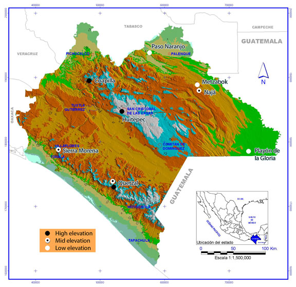
Sierra Morena (mid elevation): a small community in the biosphere reserve La Sepultura, at the north end of the Sierra Madre de Chiapas. The community itself was on an ecotone between dry deciduous forest and evergreen forest. The evergreen forest was a mosaic of different land use histories. Some areas were open coffee farms with sparse shade trees. Some areas had a closed canopy of secondgrowth trees with an understory of coffee. Some areas had oldgrowth forest canopy with an understory of either coffee or more often a palm (Chamaedorea) planted for the ornamental foliage trade. There were few areas of old-growth forest where both canopy and understory were intact.
Quetzal (mid and high elevation): Campamento Quetzal, a research and education facility near the small town of Custepec. It is in the biosphere reserve El Triunfo, at the southern end of the Sierra Madre de Chiapas. The land within a few kilometers of the building is a mosaic of old-growth forest and about 40yr old secondgrowth forest. Campamento Quetzal was used as both a mid-elevation and high-elevation site. The area around the building itself, from 1500-1700m, was used as a mid-elevation site. A ridge crest a few kilometers from the station was above 2000m and was used as a high elevation site.
Coapilla (high elevation): a small town in the central Chiapas highlands, north of Tuxtla Gutierrez. This is a highly fragmented landscape, mostly agricultural land and pine/oak forest, with only a few small patches of evergreen forest remaining. Sampling was carried out in two forest patches, between 1900 and 2000m elevation.
Huitepec (high elevation): Sampling was carried out at two sites near San Cristobal de las Casas in the central highlands. One site was Reserva Huitepec, a medium-size reserve with old-growth montane wet forest. Another site was Bazom, a forest fragment several kilometers south of San Cristobal. Both sites were about 2500m elevation.
Nahá (mid elevation): an indigenous reserve on the northern slope of the central highlands, at 900-1000m elevation. It is an area that is extensively forested, with a mosaic of different degrees of disturbance from selective logging and milpa formation.
Metzabok (low elevation): an indigenous reserve a short distance and downslope from Nahá, with elevation 570m. There are medium-sized patches of old-growth forest around a lake. The surrounding landscape has mostly been cleared for agriculture.
Both Nahá and Metzabok are islands of forest that were formerly continuous with the much larger Lacandon rainforest to the south. They have become forest islands within the last 50 years.
Paso Naranjo (low elevation): an ecotourism establishment on the Rio Tulijá, near Salto de Agua, in the northern lowlands of Chiapas. The landscape was a mosaic of forest patches and milpas (agricultural clearings). The forest patches were closed-canopy secondgrowth growing on very rocky land. The surface was highly irregular, with large limestone boulders, ledges, basins, and cracks. Elevation was 50-100m.
Playón de la Gloria (low elevation): a small community on the southern edge of the Montes Azules biosphere reserve, on the Rio Lacantún. Some sampling occurred across the river from the community, in an area of mostly old-growth tall rainforest. Some sampling occurred on the community side of the river, an area of mixed agricultural land, second growth forest of various ages, and small remnants of mature forest. Elevation was 150-200m.
To review collection gps points on Google Earth, open Google Earth, go to "Add" on menu bar, select Network Link, paste in one of following url's.
Terminology
Sample: a single miniWinkler or maxiWinkler sample. Quadrat: the 1m2 quadrats used for miniWinklers. Transect: 245m long transect, 50 miniWinkler samples at 5m spacing. Site: a locality where a pair of transects is located.
General Procedures
Day 0 (arrival). Get established in designated housing. Locate and establish site for hanging 100 miniWinkler and about 20 maxiWinkler samples. Establish two sifting teams of 5 people each. Prepare backpacks with sifting kits: 2 sifters, 2 machetes, 50 sample bags, trowels, preprinted collection code labels and data sheets, clipboard, scissors, 50 Whirlpac bags, tape measure, compass.
Day 1. Each team goes to designated miniWinkler transect site.
MiniWinkler transect: select starting point and direction of transect. Orient transects to stay within forested habitat. One person holds free end of 50m tape at starting point; second person carries tape reel and sighting compass to play out 50m tape to end. Sampling carried out on up-tape (away from start point) right side of tape, so return to start point either along tape itself or on up-tape left side, to limit disturbance of quadrats prior to sifting. Move along tape, sifting quadrats at 5m intervals. To precisely and consistently locate quadrats, carry meter stick. At 5m interval, place meter stick perpendicular to tape on up-tape right side. This marks one corner of 1m2 quadrat. Quadrat can be sited by eye using meter stick.
![]()
Use machete to macerate litter, soil, dead wood in quadrat. Sift immediately after maceration, using trowel or gardening tool to scrape litter into sifter. Sift all quadrat litter if resulting siftate is less than 3 liters. If litter is deep and abundant, such that sifting produces more than 3 l, subsample different portions of quadrat until maximum volume is reached. Place siftate in cloth bag. Cut collection code from sheet, place in Whirlpac bag, and place Whirlpac bag in cloth bag with sample. It is important to cut labels out as samples are taken in the field, rather than cutting them ahead of time, to assure maintenance of sample order and sample number. Shake sifter vigorously to remove any loose litter, to minimize contamination among quadrats, and continue to next quadrat. Guard samples in shade along the transect for gathering on return. Be sure to always keep samples in shade. Avoid compaction of samples.
When end of 50m tape is reached, use compass to continue the transect for the next 50m, dragging tape reel another 50m.
If a quadrat is partially covered by vertical tree trunk that is greater than 30cm diameter at ground level, shift quadrat to edge of trunk.
For each quadrat take litter depth data by measuring approximate litter depth (in whole cm) at each of four corners of quadrat. Centimeters can be marked on machete blade, which makes a good ruler. Record habitat and canopy condition (e.g., closed canopy mature wet forest). Make other brief notes on quadrat characteristics (e.g., moss mat from canopy in sample, shifted due to large tree in quadrat, stones or rocky surface, rotten log).
Obtain precise GPS reading of transect start point. Record in detail any changes in direction of transect, so that precise spatial map of quadrats can be constructed.
If transect comes to edge of forested habitat or otherwise impassable barrier, transect can "reflect," turning at an arbitrarily selected angle and continuing in a new direction. Choose angle that is approximately 45° or greater, so that transect does not double back too closely on itself. Do not decide to just go along a trail because it is easier.
MaxiWinkler sample: sift additional litter in general vicinity of miniWinkler transect. Select pockets of litter and rotten wood, chop with machete, and sift. When about 10 l obtained, place siftate in cloth sack in backpack and add collection code. Continue sifting until five or more bags obtained, or as time permits. Record data on location and general habitat characteristics of sifting area.
One person erects two Malaise traps in general vicinity of transect. Precisely georeference the Malaise traps. Harvest sample and take down Malaise traps at latest possible time, on the last day prior to departure for next site.
Rain: do not sift until 4hr or more after the last heavy rain. Do not sift during rain. If it starts to rain during sifting, suspend operations and wait until 4hr after rain has stopped. If rain causes a delay in sifting, schedule should be adjusted to always allow the full 3-days of extraction. The extraction period should never be shortened.
Return to Winkler-hanging facility and immediately hang samples in Winkler bags. Attach dry cup to Winkler bag. Assemble Whirlpac bag with collection code onto plastic cup sleeve. Place siftate in bucket. Scoop litter into mesh sack always over bucket (there is a rapid exodus of arthropods immediately upon placement in mesh sacks, so in the initial hanging phase any time a mesh sack is not over a bucket or Winkler bag it is suffering significant loss of material). When mesh sack is nearly full, rapidly transfer from bucket to Winkler bag. Tap any remaining loose material remaining in bucket into open mouth of Winkler bag. Jiggle Winkler bag so that loose material drops into dry cup. Quickly switch dry cup with another one. Pour accumulated dry material into top of mesh sack. If loose material continues to fall into dry cup, repeat process multiple times. Close upper Winkler bag opening with cloth sleeve. Add 95% ethanol to Whirlpac, remove dry cup and hold lower mouth of Winkler bag closed while tapping contents of dry cup into Whirlpac. Attach cup sleeve with Whirlpac to Winkler bag. Avoid any bumping of Winkler bags from then on.
Carry out similar procedure for maxiWinkler samples. Load litter in maxiWinkler bags, 4 mesh sacks per bag. Record total number of mesh sacks filled for sample.
Day 2. Teams return to transect sites. Two people begin baiting protocol, two people begin beating protocol.
Baiting protocol: Select portion of path about 100 paces long. Use 3x5 cards cut in half as baiting platforms. Lay out 20 platforms along edge of trail, at 3-pace intervals. For each platform place bait on platform. Sprinkle a small amount of bait off edge of platform. Periodically check baits, cycling among them over a 2 hr period. If only one or two ants present, do not disturb. When larger recruitment occurs, use pooter to obtain sample into Sarstedt vial and leave vial near card.
Pheidole is a genus of special concern. Pheidole have a discrete major worker caste that is important for taxonomic work. Major workers are more timid and much less abundant than minor workers. A bait recruiting many minor workers may slowly accumulate a few major workers. When pooting, go for the major workers first. At the beginning of the recruitment process, check closely for major workers. If a major worker is seen, attempt to poot it while minimizing disturbance to other workers, so that they continue to recruit. Often there is a peak in worker abundance over time, followed by a diminution as the bait is removed. Judge when peak abundance occurs and at this time attempt a fuller sample of minor and major workers. Try to poot just workers, avoiding getting much of the bait in the vials. The oil in the bait tends to coat specimens, which is bad. At the end of the sampling time, look under the platform for any workers there.
At the end of the sampling period, place vials (only those with ants; for baits where no ants arrived, reserve vials for future use) in plastic bag containing label identifying collection code, date, time, location, habitat, and collector. Do not put bait cookie in same bag with vials. Gather bait cards when finished.
In the field, a single collection code will be assigned for each batch of vials from a single person's baiting session, of the form m-c-xx-y-zz, as described below. Later, during sample processing, a subnumber will be added to make a separate collection code for each vial.
The bait of choice is crumbled Pecan Sandies.
Beating protocol: Select a portion of a trail and start beating along the sides of the trail and nearby vegetation. Maintain a collecting vial with ethanol and a collection code. Collect from head height to just above ground level on any dead or living vegetation present. Beating sheet should be placed under vegetation and vegetation struck ca 5 times in rapid succession with the beating stick. Immediately search sheet for active specimens (weevils and ants only) and collect using aspirator, featherweight forceps, or by hand. Collect into vial of alcohol. Once active specimens have been collected, search again for any cryptic and non-active specimens and collect as before. Shake sheet to discard plant debris and repeat process. Continue beating, working along trail for a 2-hour time period. This constitutes one sample. If rain starts, stop beating. In general, beating in rain is not highly productive.
Many weevils live on dead vegetation, especially tangles of vines and twigs. Special attention should be paid to fruiting and flowering plants as these plant parts are often preferred by weevils for oviposition. Learn what seem to be preferred or the most productive microhabitats.
After lunch break, people will switch roles and repeat morning sampling. Back at the base camp, check all vials that have a high specimen to liquid ratio and change etoh.
Day 3. Repeat baiting and beating protocol in two sites other than transect sites. Record locality data for new sites.
Day 4. Flexible morning and early afternoon, collecting activities planned on-site. Good time for educational activities with communities. Late afternoon: harvest Malaise traps, harvest Winkler samples, pack.
Day 5. Transport to next site.
Samples are transported back to host institution and securely stored in a refrigerator or freezer until workshop and sample processing time.
Comments on Winkler extraction efficiency
At Playon de la Gloria, a lowland rainforest site, we took a series of Winkler samples and kept track of some methodological variables and their relation to number of ants extracted. There was little or no replication, so the notes reported here are anecdotal. First, the sifter used by Jesus Luna-Cozar had coarser mesh than the other LLAMA sifters. One sample was taken with the coarse-mesh sifter and three comparable samples with the fine-mesh sifters. All of them had four mesh sacks full in the Winkler bag. The coarse-mesh sifter yielded a total of 773 ants, while the numbers for the other three were 395, 429, and 509 ants. However, another sample taken with a fine-mesh sifter but with only two mesh sacks full in the Winkler bag yielded 669 ants. There may be some diminution of ant number with the finer mesh, but if so it is not dramatic and may be small compared to other variables that impact ant number (e.g. spatial variability, litter conditions). Second, five samples were hung at the field site for one day, then put back in cloth bags in the afternoon of day 1, transported to the university in San Cristobal, rehung in Winkler bags on the morning of day 2, and taken off at the end of day 3. The proportion of ants extracted in the day 2-3 period varied from 9 to 34 percent of the total 3-day sample.
From casual inspection, there was no indication that species composition differed between coarse-mesh and fine-mesh sifters or early and late fractions.
Collection codes are a critical database linking field between individual specimen data and the ecological data connected to those specimens. Collection codes need to be rendered exactly; any deviations will break the link that allows one to look up data for a specimen or specimens for a collection. Common sources of errors are extra spaces, invisible spaces added at the end of a code, mistaking numbers for letters (e.g. the number one and the letter l, the number zero and the letter o). Although not essential, it is common for the collection code to have some information content itself. For example, different parts of the code may indicate locality or method. If the code is to contain information, it is important for the code to be fixed length, such that particular character positions or ranges convey a particular kind of information, such that codes can be decomposed using Excel formulas.
Winkler/bait/beating/Malaise samples:
General form: m-c-xx-y-zz
m = method: Wa = miniWinkler, Wm = maxiWinkler, Wx = night miniWinkler, Ba = bait, Ma=Malaise, Go=beating.
c = country code: A=Mexico, B=Guatemala, C=Honduras, D=Nicaragua (ABCD used instead of MGHN because letters M, H, N easily confused when hand written)
xx = site number: 01 to 09 for each country.
y = transect number: 1 or 2 (additional locations 3 and 4 for baiting and beating).
zz = sample number: 01-50 for miniWinklers, variable number for baiting and beating samples, 01 for maxiWinklers.
General collecting: each participant maintains a personal field notebook with a collection code series. Personal collection code series are formed by participant's initials followed by a sequential number.
Data for all collection codes are maintained in field notebooks and entered in a laptop computer when possible.
Georeferencing
Each collection code must have the following georeferencing data: latitude, longitude, gps error, extent, datum. Latitude and longitude are in decimal degrees. gps error is the error indicated on the gps unit. Extent is a distance, in meters, that reflects the maximum possible distance of the collection from the point where the gps reading was taken. This is an important concept. A Malaise trap and a series of hand collections in the vicinity of the trap may have the same gps coordinates, but the Malaise trap might have an extent of 0, while the hand collections might have an extent of 100m. Maximum error is later calculated as gps error + extent. Datum is a setting on the gps unit (for a particular projection system), usually WGS84 for Central America.
An Excel file with all collection codes has the following column headings (fields):
CollectionCode
Method
Locality short or extended (a nickname allowing grouping of collections by site, or an extended locality name that would not fit on one line of a label)
Locality label (to be printed on specimen labels)
Date start (in format dd-mm-yyyy, where month is differentiated (e.g., 12 Apr 2008 or 12.iv.2008)
Dateend (used for Malaise samples and other collections where there is a range of dates)
Collector label (Collector field for printed label, same as next field for individual collectors, "LLAMA" when general project LLAMA codes)
Collectors (individual collector, or string of initials when teams participated in collection)
Elevation (m)
Latitude (decimal degrees)
Lon neg (longitude, decimal degrees, negative for western hemisphere, allowing easy pasting into Google Earth)
Longitude (decimal degrees)
Gps error (m)
Extent (m)
Max error (m)
Datum
Habitat label (for printed label)
Habitat (can be more extensive description, more than will fit on specimen label)
Source (for hand collections, additional info such as nest characteristics or host plant; 30-character maximum field length)
Notes (any additional info about collection, including later processing history)
Country
State/Province
day (a formula entry based on date field; for specimen label creation)
month (a formula entry for specimen label creation)
year (a formula entry based on date field; for specimen label creation)
Label formula (An Excel formula that produces a text string for specimen labels; see below)
Habitat label (a formula for a habitat label)
Project LLAMA is taking an approach to specimen labels that assumes that labels are generated for specific collection codes and printed on demand for particular batches of specimens. This is in contrast to using a generalized label for a large area, with a large batch printed all at once.
Specimen labels are of the form
MEXICO, Chiapas:
2km SE Custepec
15.72298 -92.94493 ±50m
1650m, 18May2008
LLAMA#Ba-A-01-1-01
The third line of the label is latitude and longitude in decimal degrees to five decimal places regardless of error, followed by the maximum error (GPS error + extent). It is important to have the error term on the label. The fourth line is the elevation, followed by date. The collection code is printed as part of the primary label, so that georeferencing data are sure to be associated with a particular collection. Important Note: the second line is the generalized locality name, which may apply to many different gps points. Thus labels may look very similar yet differ in gps point. Thus it is important to associate a collection code with a label.
[Prior to August 2009 a different format was used, with °N and °W notation, and maximum error on the fourth line. Any specimens mounted and labeled prior to this have the older label style.]
Secondary habitat labels are of the form
Cloud forest, ex
sifted leaf litter
Collaborators can download the Excel file and use the data to construct labels as they wish, but one method is as follows:
Another option is to download this Word file (click here) that has a single copy of the label for each collection code. You can search for the collection code of interest and copy the label text.
In the Longino lab, labels are printed on an Epson Photo R1800 inkjet printer, using the recommended Epson inks. Paper is Epson Ultra Premium Presentation Paper Matte. These materials are designed to have good archival properties for professional photographers. In addition to being suitable for pin labels, the ink is not alcohol-soluble and seems to hold up well for fluid storage.
Sites are in the order they were visited.
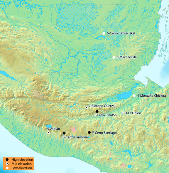
Cerro Pinalón (high elevation): Cerro Pinalón is located within the Reserva de la Biosfera Sierra de las Minas above Finca Trinidad. Sampling was carried out in an extensive area of cloud forest, at about 2500m elevation. The forest had abundant oak and pine, and in some areas bamboo was abundant.
Biotopo El Quetzal (mid elevation): Biotopo Quetzal (also known as Biotopo Mario Dary Rivera) is a reserve located near the city of Purulhá west of Sierra de las Minas. The habitat is diverse mature cloud forest. The transects were taken in the vicinity of the Reserve buildings, at around 1700m, and additional sampling was done along a trail leading up to nearly 2000m.
La Unión (mid elevation): La Unión is an area of coffee farms and extensive cloud forest, near the Honduran border south of Lago Izabal (on the south side of the Motagua fault). The forest has abundant oaks and tree ferns. Sampling was carried out between 1400-1600m.
Montaña Chiclera (low elevation): Montaña Chiclera is a municipal park of about 1000ha that protects the water source for the nearby town of Morales. It has second growth and mature lowland forest. The forest has a more seasonal aspect than the wet lowland forest of the Lacandón in Chiapas or the coastal lowland forests of Honduras, Nicaragua, and Costa Rica. There were relatively few broadleaf monocots: Heliconia, Marantaceae, Costus, etc. The two transects were located in the mature forest just behind the water reservoirs on the southern edge of the reserve, around 200m elevation.
Cerro Cahuí and Tikal (low elevation): Cerro Cahuí is a small reserve on some low hills on the north side of Lago Peten Itza. The reserve is an island of mature moist forest habitat, surrounded by rural development. About 25km north of the lake is the edge of Tikal National Park, which is an extensive area of mature forest. The forests are somewhat like Montaña Chiclera, seasonally dry, with few broadleaf herbaceous monocots. One transect was on Cerro Cahuí, the other in the center of Tikal National Park, just north of the famous Mayan ruins. Elevations were generally below 300m.
Machaquilá (low elevation): The Machaquilá forest was on private land, just north of Poptún. It was patchy forest on small limestone hills, in an area of karst topography. Although the forest had the generally seasonal aspect of Montaña Chiclera and Tikal, it seemed somewhat wetter than either of those sites, with more Heliconia, Marantaceae, etc.
Cerro Santiago (high elevation): Parque Ecológico Pino Dulce is a privately owned park between Mataquesquintla and Jalapa (on Cerro Santiago). It is located on the side of a local peak and has trails that pass through primary and secondary cloud forest. One transect was done on a high ridge around 2600m, the other on a lower ravine slope around 2300m.
Cerro Carmona (high elevation): This is a cloud forest area immediately adjacent to Antigua. It is a coffee farm and adjacent cloud forest reserve owned by a family that is very interested in conservation and developing the reserve for Ecotourism. One transect was in fairly mature second growth cloud forest at 2150m, the other in oak forest at 2350m.
Atitlán (mid elevation): Refugio Quetzal is a small research station owned by Universidad del Valle. It is located at 1600 m on the southern slope of Volcán Atitlán above Finca Panamá. The station has developed plantation land below it and mature diverse cloud forest above it. The two transects were in mature cloud forest near the station building. Some additional sampling to 2400m was carried out along a trail that continues up the volcano slope.
Sampling protocols were similar to 2008 with the following modifications.
MiniWinkler transects were carried out by teams of 4 instead of teams of 2. MaxiWinklers were not taken simultaneously. When a team finished a transect, they took a few maxiWinkler samples on the way back. More effort was made to take maxiWinkler samples at sites other than the transect sites.
Michael Branstetter added a project contrasting night versus day miniWinklers. At one low site, one mid site, and one high site, the LLAMA crew sampled a transect of 15 miniWinkler samples at night, in the vicinity of one of the standard day transects.
See notes for 2008. This year's collection codes have "B" as the second element, after the method.
See notes for 2008.
This Word file (click here) that has a single copy of the label for each collection code. You can search for the collection code of interest and copy the label text.
Sites are in the order they were visited.
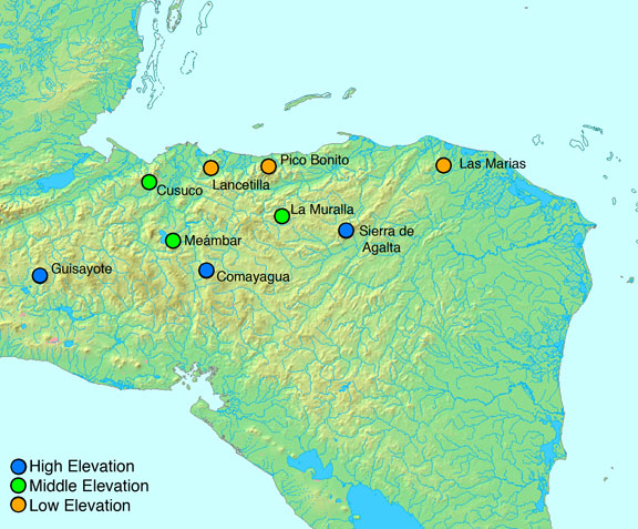
La Muralla (mid elevation): 1-5 May 2010. Parque Nacional La Muralla is a cloud forest island surrounded by the open pine woodland that covers much of central Honduras. We worked out of the visitor center at the edge of the park, at an ecotone between coffee farms and diverse mesophyll forest. A patch of forest below the center appeared to be a remnant patch of old growth, with towering Liquidambar trees. This was the site of transect 2. Forest above and to the sides of the center was perhaps 30-50 year old second growth. It was tall, closed canopy forest, but there were no really large trees. In some areas there were occasional coffee plants in the understory, reflecting a presumed history of undercutting and coffee planting. This old second growth forest was the site of transect 1. A 2hr hike up the Rio Escondido trail took one to old growth forest along a ridge top, with a high density of enormous oaks and Liquidambar trees.
La Picucha, Sierra de Agalta (high elevation): 6-13 May 2010. This site was reached by hiking through cleared areas and coffee farms to a shelter at the last coffee farm before forest began. The base camp was at this ecotone between coffee farm and diverse mesophyll forest, at about 1500m. A trail continued higher on the mountain through mature forest. Tall cloud forest continued to about 2000m elevation, above which there was elfin forest, low heath-like vegetation a few meters high, that covered the peak. The highest elevations were around 2300m. The two transects were both taken in tall cloudforest around 2000m, just below the transition to elfin forest.
Cerro Comayagua (high elevation): 14-18 May 2010. Above Comayagua there is a large cloud forest island surrounded by pine land. Along a ridge immediately behind Comayagua is a set of telecommunication towers and associated buildings, and an education center where the group stayed. The area immediately around the center was coffee farm and patches of second growth Liquidambar forest. About 2km beyond the center along the ridge there is a patch of what is probably old second growth forest. Transect 1 was taken in this patch. 2km further was the edge of primary forest. Transect 2 was taken in this ecotone between primary and secondary forest. The transects were 2000-2100m elevation.
Cerro Azul Meambar (mid elevation): 19-23 May 2010. Parque Nacional Cerro Azul Meambar is a large national park in central Honduras. It is a mountain-top cloud forest island. The group stayed at Panacam Lodge, walking to nearby forest sites for sampling.
Guisayote (high elevation): 24-28 May 2010. Guisayote is a small cloud forest reserve located about 11 km east of Nuevo Ocotepeque in the department of Lempira. The entrance to the reserve is next to the highway, at a small community called El Portillo. The locals maintain a small building that can be used to house visitors. Food and guides can be arranged with local residents. The forest consists of primary and secondary cloud forest between 2,000 and 2,400m elevation. From El Portillo there is a single road that stretches for 7-8km through the forest. Both LLAMA transects were done about 1.5km down the road in old secondary cloud forest. Additional maxiWinkler samples were collected down the road all the way to a site called La Laguna, near the border with El Salvador. This small lake has the most pristine forest, but it has restricted access due to its importance as a water source to nearby communities. Guisayote is located near the much larger Celaque and Montecristo national parks.
Cusuco (mid elevation): 29 May - 2 June 2010. Cusuco national park is located in the department of Cortés about 45km west of San Pedro Sula. Cusuco is part of the Sierra Merendón and includes 23,440ha of protected area, of which 7,690ha occur in the nuclear zone above 1,800m. The highest peak in the park is Cerro Jilinco, which reaches 2,242m. For LLAMA we arranged all of our logistics through the private company Cusuco Expeditions. This was very convenient because they have been organizing trips for the group Operation Wallacea (http://www.opwall.com/), which has several field sites spread around the mountain. The LLAMA campsite was in the forest at a place called Guanales. This was at 1,250m and provided access to mesophyll forest, pine forest, and cloud forest habitats. Both of the LLAMA transects were done in primary mesophyll forest where Liquidambar was a dominant tree. There were also lots of tree ferns and sable palms. In addition to the miniWinkler transects, maxiWinkler samples were collected from other areas in the park, including one near the peak of Cusuco in cloud forest.
Las Marias, Rio Platano (low elevation): 7-11 June 2010. The trip to Las Marias was by boat up the Rio Platano. All logistics, transportation, food, and housing was provided by Jorge Salaverri and La Moskitia Ecoaventuras. We were housed in a small community on the margins of the river, an area of small farms and young second growth vegetation. The broad alluvial plane of the river was 3-4km wide and was mostly closed canopy rainforest. The entire area was inhabited, with a long history of human use of the landscape. Shifting agriculture was common near the river. Moving away from the river there was a gradual increase in the density of larger trees. About 3km from the north side of the river the hills of Cerro Baltimore abruptly began. Where the hills began the forest quickly became of larger stature, and seemed to develop a more "primary" character. Transect 1 was on the south side of the river, in a strip of riparian forest along a stream, embedded in a matrix of pastures and young second growth forest. The forest along the stream, although narrow, had large trees and relatively low human impact. Transect 2 was north of the river, at the juncture of the alluvial plane and the foot of Cerro Baltimore. It was in an area of more extensive forest with more old-growth character.
Lancetilla (low elevation): 14-18 June 2010. Jardin Botanico Lancetilla is a large botanical garden near Tela. It has a long history, having been established in the 1920's. It is currently operated by the Honduran Escuela Nacional de Ciencias Forestales (ESNACIFOR). It has an associated forest reserve that is about 2 x 5km. The reserve is an island of lowland rainforest surrounded by an agricultural landscape. Most of the reserve is 100-400m elevation, but an extension at the south border reaches a small peak at 800m elevation. The forest has many large trees and looks like a forest that has been protected from disturbance for many decades, perhaps since the establishment of the botanical garden. There is a high density of one palm species (Astrocaryum?). Transect 1 was near the entrance to the garden, in a strip of medium-size second growth forest with an abundance of caoba (Meliaceae). Transect 2 was in the more diverse and older forest of the reserve. We also were able to take a series of maxiWinkler samples along an elevational gradient, from the southern edge of the reserve at 800m, down to the garden grounds at 100m.
Pico Bonito (low elevation): 19 June 2010. We were able to make a 1-day visit to the property of Shefik Handal, one of the LLAMA students. The property is adjacent to Pico Bonito National Park, near La Ceiba. This was relatively old second growth forest on a steep slope, at the juncture of the coastal plane and the foothills of the Pico Bonito range. Transect 1 was in forest very close to the forest edge, near small farms and extensive pineapple plantation. Transect 2 was further up the hill in more extensive forest.
Sampling protocols were similar to 2008 with the following modifications.
MiniWinkler transects were carried out by teams of 4 or 8 instead of teams of 2. MaxiWinklers were not taken simultaneously. More effort was made to take maxiWinkler samples at sites other than the transect sites.
See notes for 2008. This year's collection codes have "C" as the second element, after the method.
See notes for 2008.
This Word file (click here) that has a single copy of the label for each collection code. You can search for the collection code of interest and copy the label text.
2011 Nicaragua
Localities
Sites are in the order they were visited.
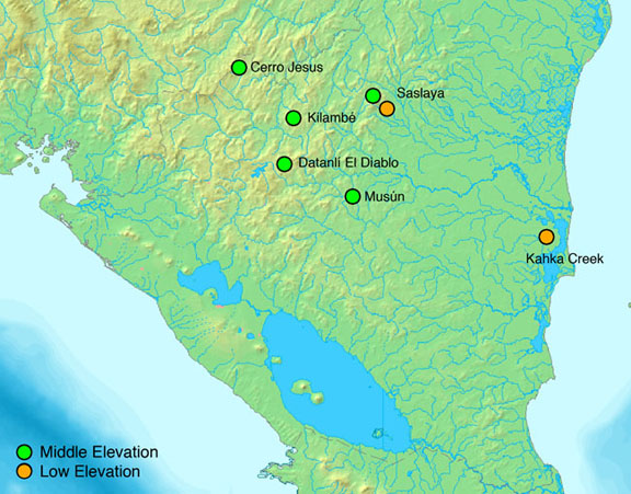
Reserva Natural Cerro Musún (mid elevation): 30 Apr-4 May 2011. Cerro Musún is an isolated mountain located in central Nicaragua (Departamento Matagalpa) east of Matagalpa and northeast of Managua. Entrance to the reserve is from the small town of Rio Blanco (4-6 hr drive from Managua). The official reserve includes 4,142 ha of protected area with good secondary and primary forest starting at about 600 m elevation and continuing up to the peak at 1,438 m. The land at the base of Musún has been converted mostly to pasture and agricultural fields. Going up the mountain, habitats include humid tropical forest, riparian forest, montane wet forest, cloud forest, and dwarf forest (nebliselva) at the peak. The park is administered by MARENA in Matagalpa and they maintain a small station at the edge of the forest. The station has a kitchen, bathroom, and a large house, which can accommodate large groups. We used this station as our base of operations during our stay. From the station there are two main trails, the “Sendero El Mojón” and the “Sendero Golondrina.” The Mojón trail leaves from the station and climbs to the peak of Musún (2-3 hrs to reach the peak). The Golondrina trail is a loop trail that borders one of the main streams near the station and passes by a series of picturesque waterfalls. The two miniWinkler transects were done near the Golondrina trail on either side of the main stream between 700 and 750 m. The habitat for both transects was primary tropical forest with abundant moist leaf litter and many large trees. We also carried out a transect of maxiWinkler collections, sampling every 50 m of elevation change from 900 m to the peak, providing a great elevational dataset for Musún. For more information about Musún, visit the official MARENA website: http://www.marena.gob.ni/index.php?option=com_content&task=view&id=193&Itemid=615.
Parque Nacional Cerro Saslaya (low and mid elevation): 6-15 May 2011. This site is located at the southern edge of the much larger Reserva de la Biosfera BOSAWAS. It is located near the mining town of Siuna and is accessible via Hormiguero from the East and Rosa Grande from the South. The park includes 631.3 km2 of protected area and is split between the departments of RAAN and Jinotega. Cerro Saslaya is an isolated peak that reaches 1,651 m with primary forest extending from 300 m to the top. Habitats include lowland tropical rainforest, montane wet forest, cloud forest, and dwarf forest. For the LLAMA expedition we hiked into the park from the small town of Hormiguero (3-4 hrs), located about 12 km to the east of the park boundary. We established our first camp at 300 m elevation in the forest next to the Río Majagua. For five days we sampled the surrounding forest. Both miniWinkler transects were done in primary forest at 270-360 m elevation. Transect 1 started at the edge of a newly made clearing, but all samples were taken in primary forest with large, old-growth trees. Transect 2 was done in similar forest, but was closer to the Majagua river and a little lower in elevation. In addition to the miniWinkler transects, a transect of maxiWinkler samples was done starting at 300 m and continuing up to 1,000 m. Samples were collected roughly every 50 m of elevation change.
After five days of sampling near the low camp, the entire camp and personnel were moved to a high camp at 1,070 m elevation (3-4 hr hike). The camp was located in a saddle between a long flat ridge and a much steeper ridge, which climbs to the peak of the mountain. The habitat was a mix of montane wet forest, riparian forest, and cloud forest. Transect 1 was done on the long flat ridge in primary cloud forest habitat at 1,110 m. Transect 2 was done closer to the camp in primary montane wet forest at 1,070 m. From the camp to the peak, all of the forest appeared primary with little disturbance. MaxiWinkler samples were collected from the camp to the peak every 50 m in elevation change except for a very steep section between 1400-1500 m. The climb to the peak from the high camp is very steep and takes about 3 hrs. For more information about Cerro Saslaya visit the MARENA website: http://www.marena.gob.ni/index.php?option=com_content&task=view&id=58&Itemid=409
Reserva Natural Datanlí-El Diablo (mid elevation): 17-21 May 2011. Datanlí-El Diablo is cloud forest reserve in the department of Jinotega. It includes 5,848 ha of protected land and has a range in elevation of 700 to 1,680 m. The reserve is administered by MARENA in Jinotega and is accessible from two roads. The reserve is a patchy matrix of private coffee farms and primary and secondary cloud forest. We accessed the park from the coffee cooperative at La Esmeralda, located about 1 hr from a turnoff on the Matagalpa-Jinotega road (km 146). At La Esmeralda we stayed in a MARENA building that has beds and running water, but no electricity. Food and guides were arranged through local people in the area. From La Esmeralda it is possible to hike up through the coffee farms and into primary cloud forest. The miniWinkler transects were done in two large forest patches between 1,400 and 1,440 m elevation. The forest appeared primary with many large oak trees and abundant tree ferns. Both forest patches were near coffee and agricultural clearings. Additional maxiWinkler samples were collected around the transect sites and up to a maximum elevation of 1,530 m. For more information about Datanlí-El Diablo visit the MARENA website: http://www.marena.gob.ni/cerro-dantal-cerro-dantal-428.
Reserva Natural Kilambé (mid elevation): 22-26 May 2011. Kilambé is located in the department of Jinotega east of the small town of Wiwilí. It includes 12,582 ha of protected area and reaches a maximum elevation of 1,750 m. Primary forest occurs above 1,300 m with the lower elevations having been converted mostly to coffee plantations, agricultural fields, and pastureland. The higher elevation habitats are a mixture of montane wet forest and cloud forest. For LLAMA, the reserve was accessed from the southeast via Valle Berlin and the farm of Pedro Blandón. We arrived to the Blandón farm by car and then hiked to the edge of the forest with hired mules and porters. All of the logistics of transporting gear and constructing a campsite near the forest were arranged with the Blandón family. From the campsite it was a quick ten-minute hike up to a ridge marking the beginning of primary forest. MiniWinkler transects were done in primary forest on top of the ridge. The forest was very wet and has an above average density of large tree ferns. The transects were located between 1400 and 1500 m elevation with transect 2 being closer to the edge of the forest. Additional leaf litter samples were collected from the transect sites up to a local high point called Cerro Hielo, which reaches 1,620 m. For additional information visit the official MARENA website: http://www.marena.gob.ni/index.php?option=com_content&task=view&id=192&Itemid=616.
Cerro Jesus (high elevation): 27-31 May 2011: Cerro Jesús is the second tallest peak in Nicaragua, reaching 1,792 m. It is located in the department of Nueva Segovia 8 km north of the agricultural town of Jalapa. The Nicaraguan side of Cerro Jesús is owned by the Jesus Mountain Coffee Company. They grow shaded coffee between 1,000 and 1,400 m elevation, but maintain primary and secondary forest up to the peak. The forested habitats include pine, and Liquidambar forests down lower, and oak cloud forest around the peak. Many of the oak trees are very large, suggesting that patches of the forest have had little to no disturbance. All logistics to work on the mountain were arranged with the owners of the coffee farm. They let us stay in a small house near the coffee and we hiked up the mountain along well-constructed trails to sample in the forest. The two miniWinkler transects were done in oak cloud forest in areas that appeared pristine. Transect 1 was done lower down the mountain between 1,600-1700 m. Transect 2 crossed the peak of the mountain and had an average elevation of 1,700 m. Additional leaf litter samples were collected from 1,000 m up to the peak. For more information about Cerro Jesús visit the Jesus Mountain Coffee Company website: http://www.jesusmountaincoffee.com/jesus_mountain.htm.
Reserva Natural Kahka Creek (low elevation): 5-10 Jun 11. Kahka Creek is a privately managed preserve within the larger Rio Wawashang Nature Reserve. It is located in the RAAS department near La Laguna de Perlas and the town of Wawashang. Rio Wawashang is a true paper park, with an ever-expanding frontier farming town in the middle of it (Pueblo Nuevo). The preserve is about 600 hectares of mixed primary and secondary forest and in 2005 it was hit by hurricane Beta, flattening most of the larger trees. Another hurricane hit in 2009, further affecting the forest. As a result, the preserve contains almost no closed canopy forest and the understory is usually densely vegetated. Kahka Creek is managed by FADCANIC, an NGO that also has a forestry technician school that services the region. The preserve maintains a staffed research station at the edge of the park that can easily house and feed large groups. The miniWinkler transects for LLAMA were done in areas that used to be tall primary forest, rather than pastureland. Both transects were between 0-50 m elevation. Additional maxiWinkler samples were collected from other sites within the preserve. To arrive at Kahka Creek, we drove to the town of Rama (5 hrs from Managua) and hired a boat to take us to Pueblo Nuevo via Laguna de Perlas (3 hrs). From the river it was a 30 min hike to the station. For more information visit the website of FADCANIC: http://www.fadcanic.org.ni/?q=es/node/32. A video showing the forest and station at the preserve is available on YouTube: http://www.youtube.com/watch?v=4mbLf50fLzE.
Sampling protocols were similar to 2008 with the following modifications.
MiniWinkler transects were carried out by teams of 4 or 8 instead of teams of 2. MaxiWinklers were not taken simultaneously. More effort was made to take maxiWinkler samples at sites other than the transect sites.
See notes for 2008. This year's collection codes have "D" as the second element, after the method.
See notes for 2008.
This Word file (click here) that has a single copy of the label for each collection code. You can search for the collection code of interest and copy the label text.