
Field Notes:
2nd Location at Dry Falls: Mossbottom Pothole
Pothole off of Jeep Trail
Approximately ¼ of a mile east of Deep Lake dock
October 13th, 2012
Noon
Weather/Atmosphere:
Overcast, slight rain
Cold, breezy
Sounds:
Bird calls, near and distant
Echoing
Small birds chirping inside the pothole
The flapping of a crow (or raven)’s wings very clear
Geese in distance from Deep Lake
Even bugs audible
Movements of team members, any speaking among them very clear
Highway 17 still slightly audible
Measurements:
< 75 feet diameter
75 feet deep
Composition:
As throughout entire Dry Falls location, there are dry grass clusters and sage brush covering the outside land around the potholes
Semi-perminent talus makes up the hole’s walls, covered by moss and lichen
Lots of dead grass, mostly dry and yellow
The bottom is more or less flat and its area is about half of the total area of the pothole – the other half is rocky slopes. These slopes consist of first ledges, then piles, and finally slopes of fist to head-sized rocks of basalt. The rocks here are even more crumbly than at the Dry Falls Lake location and large piles of sediment and dormant lichens and mosses have collected everywhere.
Observations on soil:
Firm to ground or all clumped together
From a medium shade of brown to a dark brown
Culture:
Power lines visible in distance
Jeep trail, the trail we came on
Other Notes:
We are all sitting at the edge of the pothole facing it
A Redtailed Hawk flew out of the neighboring pothole
Concentration of Life within: bird activity within, plant-life within
Lots of deer scat and deer trails around
Signs of recent rainfall
Mostly reddish-brown, some gray rocks
No concrete evidence of what caused the cavitation tornado (perhaps disapeared over time)
Does not currently contain any water at the bottom, but does hold moisture
Unable to see the bottom because of the density of plant life
The vast open space of the general area lends to an awareness of what’s to come, a safe place for wildlife?
Cliff faces feel like walls of a place
Higher elevation (than camp and Dry falls lake)
Cliff faces seem to have more talus, potholes themselves have lots of talus. (Rocklayer less stable at higher elevation?)
Rocks are not smooth
Pothole is very circular
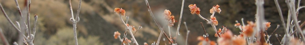
Trees are deciduous, small leaves, more shrublike, as if stunted
The trees must rely on the precious water and shelter this natural feature provides to grow at all in this region. The only other place trees can survive in this region is directly adjacent to a substantial water source such as a lake or creek.
The trees are about twenty to thirty feet in height and are made up of thin, branched trunks with many, many branches waving and shooting up in wiry spires. At this point in the season about half of the year’s leaves have fallen to the ground while the other half remain in the trees. They are a variety of green, orange, yellow, and red. Some of the bushes and trees have small berries all black and dark purple and shriveled up, but are gone, either eaten by the birds or fallen to the ground.
Many fallen leaves concentrated on the pothole floor, and vibrant moss
Most plants fall into the tan, light golden, or yellow shades of this arid region
The silence and therefor volume of any action makes this a very dramatic place, by contrast
There are many of bushes and shrubs at the bottom of the pothole. Their colors range from deep, burnt orange to pale, guacamole green.