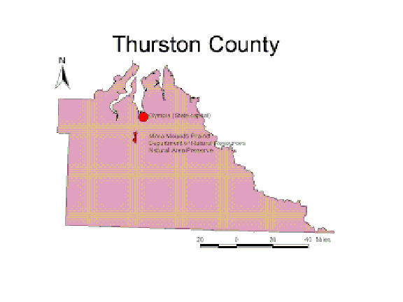
Mima Mounds Prairie is located just northwest from the center of Thurston County approximately 20 miles south of Olympia, Washington. The Bowen-ratio instrument is positioned in an intermound location within the natural area preserve.
Mima Mounds of Thurston County
A Study of Evapotranspiration,Geologic History
& Myths
LOCATION
Mima Mounds Prairie is located just northwest from the center
of Thurston County approximately 20 miles south of Olympia, Washington. The
Bowen-ratio instrument is positioned in an intermound location within the natural
area preserve.
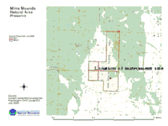
Mima Mounds Prairie is a geologically unique area consisting of large unexplained mounds that are either round or elliptical in shape, standing from one-half meter to about two meters in height, and having a diameter from two and one-half meters to three meters. It is situated about one kilometer west-southwest of Littlerock in southwestern Thurston County in portions of sections 3, 4, 9, and 10, Township 16 North, Range 3 West (Willamette Meridian). Surrounding the mounds are the Black Hills to the west and the Black River to the east.
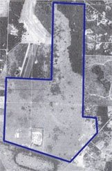
Aerial photo of Mima Mounds
Prairie Natural Area Preserve
INTRODUCTION
Evapotranspiration (ET), the process of transferring moisture from the earth to the atmosphere by evaporation of water and transpiration from plants, is of great importance in the hydrologic cycle. This study used micrometeorological measurement to determine ET from the energy balance of Mima Mounds Prairie. The energy balance consists of four major components: net radiation input, energy exchange with soil, energy exchange to heat the air (sensible heat) and energy exchange to evaporate water (latent energy). Latent energy is thus the budget involved in the process of evapotranspiration:
Net Radiation -Ground Heat Flux = Sensible Heat + Latent Energy
In 1956 Penman defined potential ET as "the amount of water transpired in unit time by a short green crop completely shading the ground, of uniform height and never short of water." So, in theory, if Mima Mounds Prairie had ample soil water and "a short green crop", then the actual ET measured by the Bowen ratio energy balance method should equal the potential ET.
While the Penman equation provides estimates of potential ET, the Penman-Monteith equation takes into account the resistance to heat and vapor movement from open soil and vegetation and is suitable to estimate actual ET. The Penman-Monteith equation used is
LE =( s(Rn - G) + PCp (es - ea) rh) /(s +( L(rc + rh))/ rh) (Tomlinson 1994)
When using the Bowen-ratio energy budget method (Bowen 1926) to estimate ET, the difference between Rn and G is the energy transported upward by Sensible Heat (H) and Latent Energy (LE), but the relative values of H and LE cannot be calculated wholly from the energy budget. The Bowen-ratio (B) is the ratio of H to LE. B, also a function of the heat capacity and density of air and vapor pressure.
B = (PCp x DT)/ L e (es - ea) (Tanner 1988)
Now we can calculate the latent energy (LE) in terms of the Bowen-ratio, sensible heat flux (H) and latent energy of vaporization using a formula from Campbell (1977), we can derive evapotranspiration (ET). ETd = 86.4 x SLE/SL