Mima Mounds of Thurston County
A Study of Evapotranspiration,Geologic History & Myths

Geologic History

The prairies of lowland Puget Sound are situated on stratified glacial outwash left by the last Ice Age (14,000 YBP). One lobe, Vashon Stade, worked its way down through Puget Sound, stopping just south of what is now Olympia, the state capitol. The stratification was created by a series of meltwater-channel stages covering about one thousand years time. "Glacial drainage through…[the Chehalis Valley] channel diminished substantially about 13,000 years ago…" After the building of outwash subsided; the ground was left barren, and open to introductory species of native plants. From sediment core samples taken at nearby Mineral Lake, pollen profiles showed plant communities dominated by Picea and Pinus (Spruce and Pine respectively). As the climate changed, becoming warmer and stabilizing, these conifers declined and were replaced by Pseudotsuga and Pteridium aquilium (Douglas Fir and Champlain's brackenfern). These two periods lasted in succession until approximately 7,000 years ago. Little is known about this last 7,000 years. It is believed that aborigines inhibited the re-growth of trees on the prairies in this area by burning until possession of the land by settlers in the 1850's. This was done in order to harvest the local camas root (a food source), and would explain the high soot content of the A-horizon soil found on the prairies.

Surrounding the Mima Mounds Prairie are the Black Hills to the west and the valley of the Black River to the east. The Black Hills are of Pleistocene origin and formed the western border of the eastern lobe of the Vashon glacier. The Black River was one of the drainage channels of the retreating ice front. It is now just a small river, too small to account for the size of the river valley. The area in which Mima Mounds Prairie lies is in one of the scores of the terminal moraine of the Vashon glacier. Drainage from the glacier passed over this area, but converted to the Black River as time went on. Eventually, all drainage in the area went into the Chehalis River.


Myths and Other Speculations

Gopher Theory

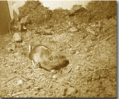
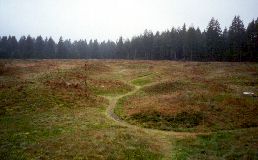
It is favorably believed that the origin of the Mima Mounds was wholly the responsibility of the Mazama (northwestern) Pocket Gopher (Thomomys talpoides).
Dalhquest and Scheffer, professors from the University of Washington, stated that Mima mounds were formed by pocket gophers or similar animals that tunnel outward from their nest sites, causing the backward displacement of soil. They suggested that the mounds are found where such mammals nest year after year. The nests, and thus the mounds, are at a fixed distance from one another because of territorial requirements. Fossorial rodents, such as pocket gophers, can survive only in high spots where the soil is well drained. If such spots exist, the animals establish their nests in them every year. Since gophers usually dig their foraging tunnels outward, they continually displace soil toward the nest. The soil they mine is pushed backward through the tunnel system before being deposited on the surface or packed into an abandoned chamber.


Paul Bunyan

Paul Bunyan is said to have brought logging to the Pacific Northwest. Not only did he dig Puget Sound, to float huge logs to the mill, he created the mounds at the Mima Prairie. Oh, he also scooped out the Great Lakes to provide drinking water for his giant blue ox, Babe. The legend of Paul Bunyan began with the exaggerated stories and boasts that were exchanged in the bunkhouses of lumber camps from the Great Lakes region to the West Coast.


Seismic Activity

Mima Mounds could instead be the consequence of seismic activity. This was done experimentally by subjecting a plywood board covered with a thin veneer of loess to impacts that produce vibrations in the board.
In the experiment, the mounds had characteristics that are similar to those found in the field. This may suggest that most Mima mounds formed as the result of seismic activity in conjunction with unconsolidated fine sediments on a relatively rigid planar substratum.
Weekly Photos Introduction Methods Results & Conclusion USGS Map HOME Flora