Figure 8. Trends and comparison of ET using Penman-Monteith and Bowen-ratio methods.
Mima Mounds of Thurston County
A Study of Evapotranspiration,Geologic History
& Myths
Results - Evapotranspiration
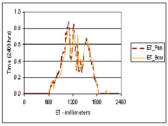
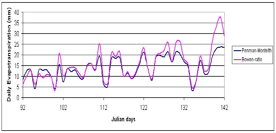
Net radiation, relative humidity, soil heat flux, and temperature all showed increases and decreases accordingly from about 9:00 a.m. to 6:00 p.m. each day. During the evening hours until morning and on rainy days, the high humidity precluded calculation of evapotranspiration. This was due to the dew vapor pressure (ea) and saturated vapor pressure (es) being equal, creating a "division by zero" error on Excel. During daylight hours, relative humidity and soil heat flux were inversely related with net radiation and temperature. Latent energy showed the same trend as net radiation, but at a fraction of the watts per meter2. Evapotranspiration also showed this trend. A comparison was made of the Penman-Monteith method of potential ET with a canopy resistance factor against actual ET using the Bowen-ratio method. The comparison showed a matched path of readings and calculations sufficient to accept the Penman-Monteith method as actual (Figure 8). A correlation of the two methods for Julian day 108 exhibited a linear relationship with a R2 of 0.9834, and a regression line with a slope of 0.9852 and an intercept of 0.0049 (see Figure 9). Julian day 115 had a R2 of 0.9756. A comparison of the two methods for the days between Julian day 92 and day 138 without high humidity exhibited a R2 of 0.9476 (y = 1.0398x + 0.0819), and comparing the two methods for all days (regardless of weather) showed a R2 calculation of 0.9103 (y = 1.167x + 1.156). ET showed daily measurements ranging from 3.4 mm to 23.7 mm using Penman-Monteith and 3.6mm to 37.6mm using the Bowen-ratio method. There was no correlation between daily rainfall and evapotranspiration (R2 = 0.17).
Water content of the soil and soil bulk density were important components in calculating soil-heat flux (G). Both were determined from the average of several measurements equaling 0.19 cm3/cm3 for water content (W) and 699 kg m-3 for bulk density (Pb).
Figure 8. Trends and comparison of ET using Penman-Monteith
and Bowen-ratio methods.
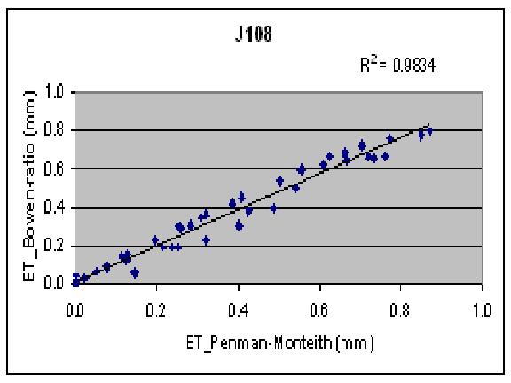
Figure 9. Correlation plot of Penman-Monteith method versus
Bowen-ratio method.
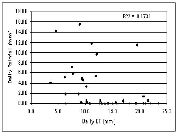
Figure 10. There appears to be no correlation in this plot of
rainfall versus evapotranspiration.
CONCLUSION
In comparing the three different soil horizons, there was a significant reduction in ion content with respect to increased depth (F = 3289.8, P < 0.0001). The highly porous and permeable soil in this area is consistent with A-horizon soils low in water soluble ions, and B and C-horizon soils even less so. An analysis of the local water might help determine whether the specified ions filter through to the groundwater or if the concentrations are also low in adjacent groundwater.
The main purpose of this study was to correlate the two methods for determining evapotranspiration. ET using Penman's calculation with a canopy resistance factor came very close to the results for actual ET using the Bowen-ratio method. It was a real challenge to manipulate all the data using several steps and a variety of different software and equipment to achieve the proper measurements for evapotranspiration.
Rainfall was found not to affect ET calculations except by altering relative humidity. When humidity was at 100%, the 21X data obtained did not permit calculations of evapotranspiration.
This study found a close correlation of evapotranspiration using the Penman- Monteith method for determining potential evapotranspiration with the added canopy resistance factor and the Bowen-ratio method determining actual evapotranspiration (mean daily R^2 of 0.91). The correlation improved to R^2 = 0.95 for all days without very high humidity. The methods complimented each other in affirmation of results. Components of the instrument used in obtaining needed readings for calculations were uncomplicated and relatively easy to maintain. These combined methods would be worthwhile in future studies of evapotranspiration. It should be possible to initially establish a correlation between the two methods at a study site. Once established, the Penman-Monteith method could be continued and the more difficult Bowen-ratio method suspended except periodically for calibration or confirmation of the Penman-Monteith measurements.
References:
Bowen, I. S. 1926. The ratio of heat losses by conduction and by evaporation from any water surface. Phys. Rev. 27: 779-787.
Bretz, J.H., 1913, Glaciation of the Puget Sound Region: Washington Geological Survey Bulletin 8, p. 239.
Campbell, G.S., 1977, An introduction to environmental biosphysics: New York, Springer-Verlag, 159 p. CSI Bowen Ration Instrumentation Instruction Manual. Rev 1/91 1991 Campbell Scientific, Inc
Dahlquest, W.W., Scheffer, V.B., 1942, the origin of the Mima Mounds of western Washington: Journal of Geology, v. 50, no. 1, p. 68-84, and Scheffer, V. B., 1947, the mystery of the Mima Mounds: Scientific Monthly, v. 65, no. 3, p. 231-234.
Giles, L.J., 1970, The Ecology of the Mounds on Mima Prairie with Special Reference to Douglas-Fir Invasion; Master thesis, University of Washington, p. 13-20.
Penman, H.L. 1956. Evaporation: An introduction survey. Neth. J. AGR. Sci. 4:8-29.
Schultz, C.B., Smith, H.T.U., 1965, International Association for Quaternary Research VIIIth Congress, guidebook for field conference J., Pacific Northwest, Aug-Sept. 1965.
Tanner, B.D., 1988, Use requirments for Bowwen-ratio and eddy correlations determination of evapotranspiration-Proceedings of the 1988 special conference of the Irrigation and Drainage Division: Lincoln, Nebraska, American Society of Civil Engineers, 12 p.
Tomlinson, S.A., 1994, Instrumentation methods, and preliminary evaluation of evapotranspiration for a grassland in the Arid Lands Ecology Reserve, Benton County, Washington, May-October 1990: U.S. Geological Survey Water-Resources Investigations Report 93-4081, 32 p.
United States Department of Agriculture, 1990, Soil Survey of Thurston County, Washington, p. 238.
Washburn, A.L., 1988, Mima Mounds, An evaluation of proposed origins with special reference to the Puget lowlands, Report of Investigation 29, 1988, p. 4.